Chugach National Forest covers 5.5 million acres of southcentral Alaska, making it the second-largest national forest in the United States. The forest stretches from the Kenai Peninsula east across Prince William Sound to the Copper River Delta, encompassing a landscape that shifts between glaciated peaks, dense Sitka spruce rainforest, alpine meadows, and some of the most productive salmon streams in the world. This is not a manicured recreation area with paved interpretive paths. It is a working wilderness where weather changes fast, distances are real, and the wildlife is genuinely wild.
Anchorage sits at the forest's northwestern edge, which means several million Alaskans have one of North America's most dramatic backcountry landscapes as their practical backyard. Flattop Mountain, technically within Chugach State Park but deeply linked to the forest ecosystem, gets climbed thousands of times each summer by Anchorage residents on their lunch breaks. Further south and east, the character of the land changes entirely: glaciers calve into fjords, black bears fish alongside brown bears in the same creek bends, and the scale of everything expands in ways that feel genuinely humbling.
The Copper River Delta at the forest's eastern edge is one of the most important shorebird staging areas in the Western Hemisphere, hosting millions of migrating birds each spring. Whether you are planning a weekend backpack on the Resurrection Pass Trail or a week-long paddling trip in Prince William Sound, Chugach rewards careful preparation. Read the how to check conditions before you go guide before any Alaska backcountry trip.
Why Chugach Stands Out
Scale and Wildness That Earn the Description
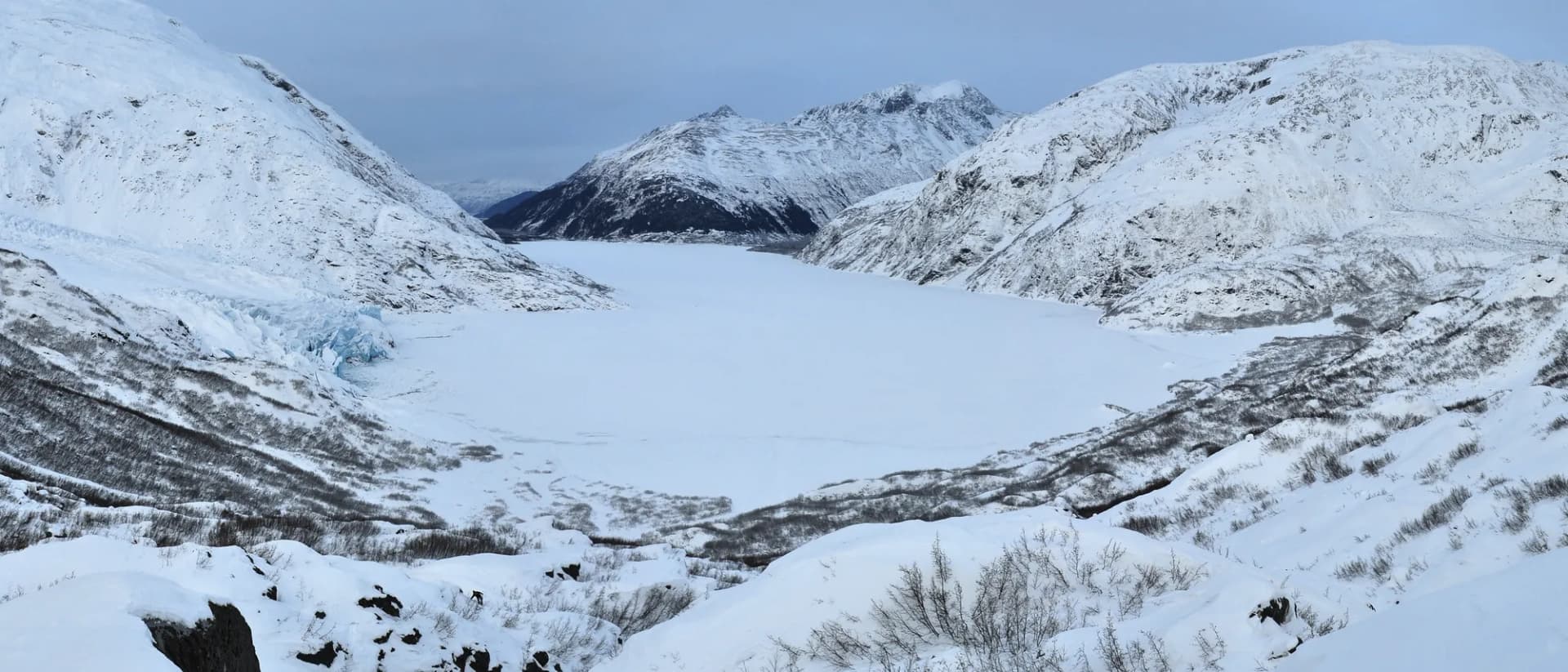
Five and a half million acres is large enough to swallow most Lower 48 states. Within that area, Chugach contains over 100 named glaciers, including the vast Harding Icefield on the Kenai Peninsula (technically straddling Kenai Fjords National Park), the Columbia Glacier in Prince William Sound (one of the fastest-retreating glaciers on Earth), and dozens of smaller valley glaciers accessible on foot. The forest also contains six wilderness areas totaling about 1.3 million acres, where mechanized equipment is prohibited and the trail network is deliberately sparse. Solitude in the Alaska backcountry is still achievable here in ways that are increasingly difficult in the Lower 48.
Wildlife Density and Variety
Chugach supports concentrations of wildlife that few continental forests can match. Brown bears and black bears share the landscape. Moose are common throughout, particularly in riparian corridors and at forest edges. Dall sheep occupy the high alpine ridges. Wolverine, wolf, lynx, and river otter all live here, though most require patience to see. The marine edge adds Steller sea lions, harbor seals, sea otters, orca, and humpback whales. The forest's salmon streams draw bears and eagles in numbers that feel almost theatrical during peak runs in late summer.
The Cabin System
Chugach maintains a network of 42 public recreation cabins spread across the forest, accessible by foot, ski, floatplane, or boat. These are simple structures: wood stove, bunks, outhouses, sometimes a canoe or skiff for water access. Reservation fees run roughly $45-65 per night (as of 2026) through Recreation.gov, which is a remarkable bargain for an Alaska backcountry experience. The cabins along the Resurrection Pass Trail are among the most-booked in the Alaska cabin system, and weekends in July fill months in advance.
Best Trails in Chugach National Forest
Resurrection Pass Trail
The full Resurrection Pass Trail runs 38 miles from Hope to Cooper Landing, crossing the Kenai Mountains at 2,600 feet and passing through spruce-birch forest, alpine meadows, and tundra. Day hikers typically access the southern terminus near Cooper Landing for an out-and-back section to the pass area, gaining good views of the surrounding peaks with a manageable 10-mile round trip. The trail is also a popular ski and snowmachine route in winter. Cabin reservations along the route should be made months in advance for peak summer weekends.
Flattop Mountain
Anchorage's signature hike sits at the edge of Chugach State Park with direct city access from the Glen Alps trailhead. The Flattop Mountain route climbs 1,350 feet in 3.5 miles round trip, finishing on an open rocky summit with views across Cook Inlet to Denali on clear days. The final hundred feet require hands-and-feet scrambling over loose rock. The trail is extremely popular on summer weekends; early starts avoid crowds and parking issues at the trailhead.
Lost Lake Trail
The Lost Lake loop near Seward is a 16-mile circuit that climbs from spruce forest at sea level into open alpine terrain above treeline, reaching an alpine lake at roughly 1,900 feet before descending. Most hikers do this as a two-day backpack, though strong day hikers complete it in 8-10 hours. Trail surface alternates between rooted singletrack, boggy tundra, and rocky ridgeline. This is one of the best routes in the forest for late-season berry picking and fall color.
Power Creek Trail
Starting from Cordova, the Power Creek Trail accesses a dramatic valley surrounded by hanging glaciers, waterfalls, and steep peaks. The 8.6-mile out-and-back gains 2,500 feet and ends near the Power Creek cabin, which sits below several active glaciers. Cordova is accessible by ferry or floatplane, which filters the crowds and keeps this trail notably quieter than Kenai Peninsula routes despite its quality.
Permits and Passes
Most day hiking in Chugach requires no permit or fee as of 2026. Some trailhead parking areas charge a small day-use fee; verify current requirements at the Seward Ranger District or Glacier Ranger District offices. Backcountry camping throughout the forest is free with no permit required.
The Recreation Pass (also called the America the Beautiful Pass) provides access at fee sites across the national forest system. Veterans and active military can access this pass at no cost. See veteran benefits on national forests and the America the Beautiful pass guide for details.
Cabin reservations go through Recreation.gov. Popular cabins on the Resurrection Pass corridor book out 6 months in advance for July and August weekends. Check the Recreation.gov listing for current availability and pricing, as fees are subject to change.
Camping
Chugach offers developed campgrounds along the Seward Highway and Sterling Highway corridors, plus dispersed backcountry camping throughout the forest. Bertha Creek Campground sits along Sixmile Creek in a classic spruce forest setting and fills quickly on summer weekends. Ptarmigan Creek Campground near Mile 23 of the Sterling Highway is near good fishing and has reservable sites.
Dispersed camping is permitted throughout the national forest outside of day-use areas and wilderness areas where camping is restricted to specific zones. No campfire permit is required, but campfires are strongly recommended against in dry conditions during late summer. A lightweight backpacking stove is more practical for most Alaska backcountry trips anyway, given frequent rain and the difficulty of finding dry wood in coastal rainforest zones.
Bear canisters or approved hanging techniques are essential for food storage at all backcountry camps. Bear canister requirements vary by location; check current USFS guidance. The forest cabins typically include bear boxes or caches.
When to Visit
June through September covers the primary hiking season. Early June brings snow at elevation and soggy trails at lower elevations. By mid-June, most trails below 3,000 feet are open, wildflowers are at peak, and daylight is nearly continuous (Anchorage sees roughly 19.5 hours of daylight at summer solstice). July is generally the warmest and driest month, though temperatures rarely exceed 70 degrees Fahrenheit even at lower elevations.
August brings berry season, salmon runs in the streams, and the first hints of fall color in the alpine zone. September is spectacular for color but increasingly rainy and cold at elevation. Snow can return to passes by late September. Winter visitors find excellent ski touring, snowshoeing, and cabin access across the forest, particularly on the Kenai Peninsula.
Be prepared for rain at any time of year. Coastal and transitional zones in Chugach receive 60-100 inches of precipitation annually. High-quality waterproof gear is not optional in Alaska hiking. Review current conditions through the checking conditions guide and the USFS Chugach district offices before departure.
Getting There
From Anchorage: The Seward Highway (AK-1) heads south through the forest within 30 miles of downtown. Portage Valley, Byron Glacier, and Crow Pass area trailheads are 50-60 miles south. The Kenai Peninsula trailheads (Hope, Cooper Landing, Seward area) are 90-130 miles south via the Seward and Sterling highways.
From Seward: Seward sits at Mile 127 of the Seward Highway and serves as the hub for Lost Lake, Resurrection Pass (southern terminus), and several other trails. Alaska Railroad runs a seasonal train between Anchorage and Seward.
From Cordova: Cordova is not connected to the road system and is reached by ferry (Alaska Marine Highway) or small aircraft. This filters access to the Copper River Delta and Prince William Sound trails effectively.
Most visitors fly into Ted Stevens Anchorage International Airport. Rental cars are essential for trailhead access outside the Anchorage bowl.
Practical Tips
- Bear spray is strongly recommended and widely considered standard equipment for Alaska hiking. Carry it accessible, not in your pack.
- Mosquitoes are genuinely relentless in low-elevation areas from late June through early August. Head nets and DEET-based repellent are the practical solution.
- River crossings are common on backcountry routes and can be dangerous in early summer snowmelt. Trekking poles, unbuckled hip belts, and knowing basic swift-water crossing techniques are worth reviewing before off-trail travel.
- Cell service is limited or absent on most Chugach trails. A satellite communicator (SPOT, Garmin inReach) is strongly recommended for backcountry trips.
- Alaska driving distances are longer than they look on a map. Plan extra time for road travel, particularly on gravel roads to remote trailheads.
Planning Your Trip
The Chugach National Forest website at fs.usda.gov/chugach has current trail conditions, cabin availability links, and district office contact information. The Seward Ranger District (based in Seward) and the Glacier Ranger District (based in Girdwood) cover the most-visited areas.
For trip planning context, reviewing national forest vs. national park clarifies the different rules that apply in Chugach versus Kenai Fjords National Park, which shares the Kenai Peninsula. Leave No Trace principles are particularly important in Alaska's sensitive tundra and wetland ecosystems. See the Leave No Trace guide for principles adapted to backcountry travel.
Camping permits and group size limits apply in some areas; verify current rules with the ranger district before your trip. How to get a national forest camping permit covers the general process, but Alaska-specific rules can differ from Lower 48 procedures.