Pisgah National Forest covers over 500,000 acres of western North Carolina's Blue Ridge Mountains, stretching across a patchwork of ridges, valleys, and river gorges from the Tennessee border to the foothills south of Asheville. It is one of the oldest national forests in the eastern United States and holds a unique place in American conservation history. This is where scientific forestry in the U.S. began, on the former Vanderbilt estate lands that George Vanderbilt hired Gifford Pinchot (and later Carl Schenck) to manage in the 1890s. When the federal government purchased those lands in 1916, Pisgah became one of the first national forests established under the Weeks Act east of the Mississippi.
History aside, the practical appeal is straightforward: Pisgah has more waterfalls, more trail miles, and more elevation variety than almost anywhere else in the Southeast. If you're based in Asheville, the forest boundary is a 20-minute drive. If you're based in Brevard, you're practically inside it already.
Why Pisgah Stands Out
Three things set Pisgah apart from other national forests in the region.
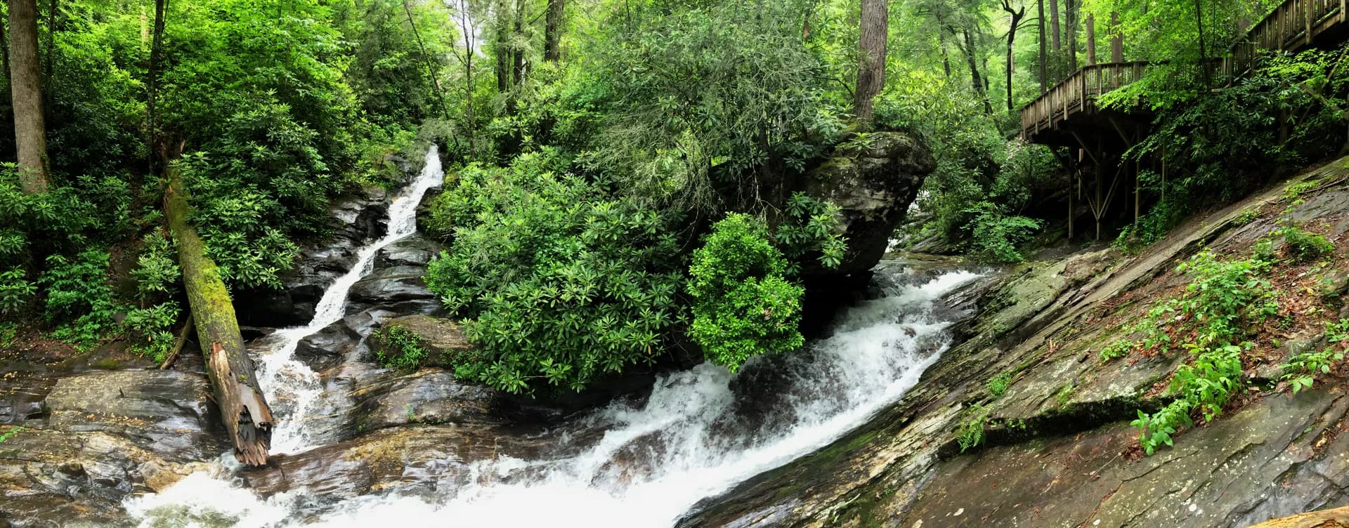
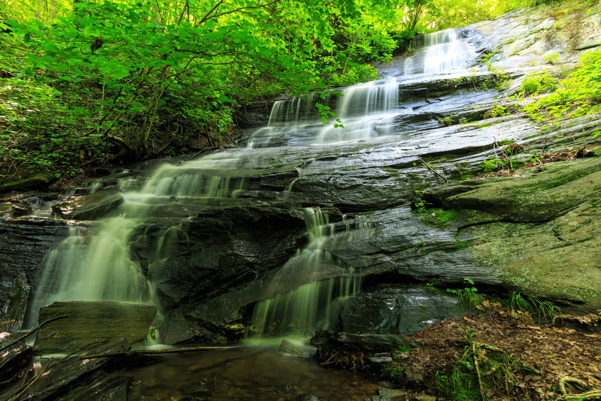
Waterfalls. Pisgah contains over 250 waterfalls within its boundaries. Some, like Looking Glass Falls (a 60-foot cascade visible from the road on US-276), require zero hiking. Others, like Catawba Falls, Moore Cove Falls, Courthouse Falls, or the triple-tiered Triple Falls at DuPont State Recreational Forest nearby, require short to moderate hikes. The concentration of waterfalls here is unmatched anywhere east of the Rockies. The geology is responsible: ancient metamorphic rock, high annual rainfall (60 to 80 inches in some areas), and thousands of feet of elevation change create the perfect conditions for water to find dramatic ways downhill.
The Cradle of Forestry. The Cradle of Forestry Historic Site, located along US-276 in the forest's Pisgah Ranger District, marks the spot where Carl Schenck established the Biltmore Forest School in 1898. This was the first forestry school in North America. The visitor center tells the story well, with a short film, two interpretive trails, and restored buildings from the original campus. It is open seasonally (typically mid-April through early November) and charges a $6 per adult admission fee. If you care about public lands and how they came to exist, this is worth an hour of your time.
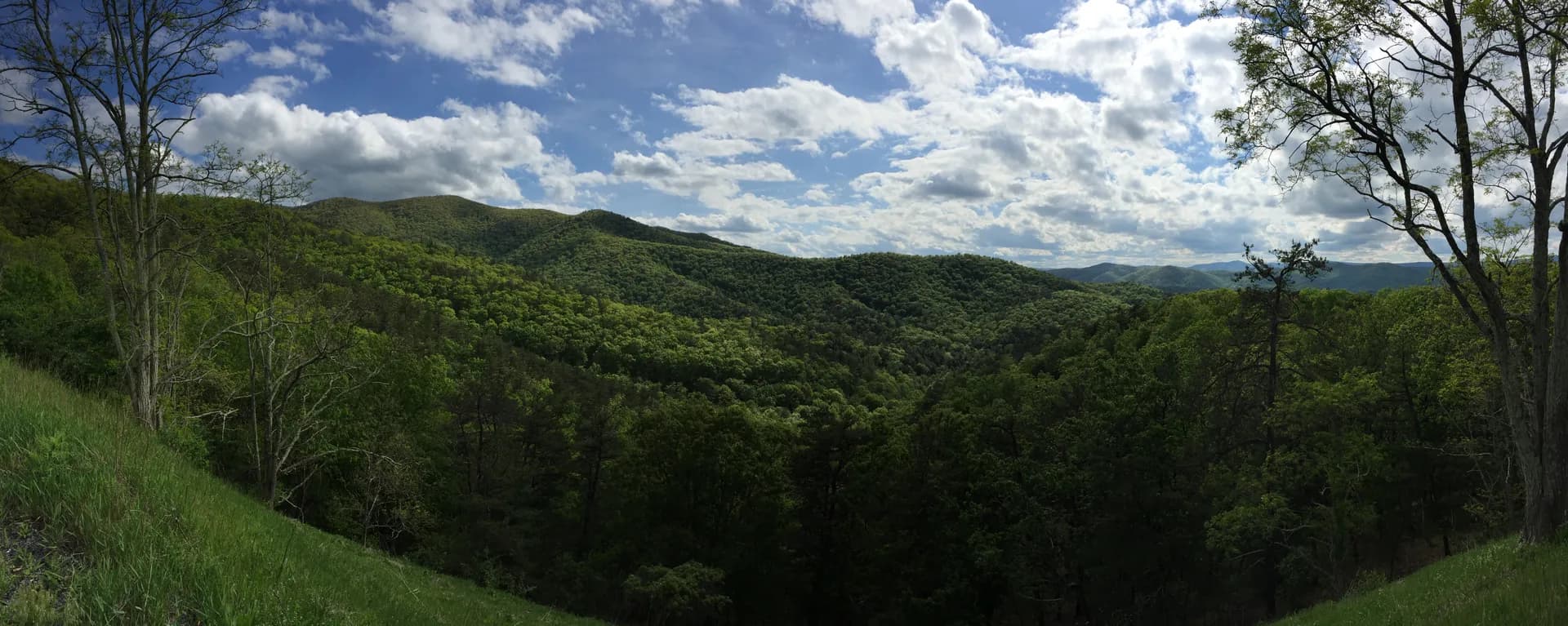
Blue Ridge Parkway access. The Blue Ridge Parkway runs directly through Pisgah National Forest for dozens of miles, with pulloffs, overlooks, and trailheads along the way. Several of the forest's best hikes (Graveyard Fields, Black Balsam Knob, Richland Balsam) start from Parkway trailheads above 5,000 feet. The Parkway itself provides some of the best windshield scenery in the Appalachians, especially during fall color season in October.
Best Trails in Pisgah National Forest
With over 300 miles of trails spread across multiple ranger districts, Pisgah can feel overwhelming. Here are four of the best.
Looking Glass Rock Trail
The signature hike. This 6.2-mile out-and-back climbs 1,700 feet through hardwood forest to the summit of Looking Glass Rock, a granite pluton that rises 400 feet above the surrounding canopy. The rock face is visible from miles away and is a landmark for the entire Pisgah district. The trail climbs steadily with a series of switchbacks, and the final push to the open summit delivers panoramic views of the surrounding Blue Ridge. On a clear day you can see the Pisgah Ridge, the Blue Ridge Parkway corridor, and the peaks of the Shining Rock Wilderness. The trailhead is on FR-475, about 10 miles from the Pisgah Ranger Station on US-276. Arrive early: the small parking lot fills fast on weekends.
Max Patch
A 2.4-mile loop on a grassy bald along the Appalachian Trail near the Tennessee border. Max Patch sits at 4,629 feet and offers unobstructed 360-degree views of the Great Smoky Mountains, the Black Mountains, and the Bald Mountains. The hike itself is easy (350 feet of elevation gain), making it accessible to almost anyone. The real draw is the open sky: Max Patch is one of the best sunset and stargazing spots in the southern Appalachians. On clear nights, the Milky Way is visible. The drive from Asheville takes about 75 minutes via I-40 and NC-209. Bring a blanket and plan to linger.
Graveyard Fields Loop
A 3.2-mile loop off the Blue Ridge Parkway at milepost 418 (just down the road from Devils Courthouse at milepost 422), starting at over 5,100 feet elevation. The trail drops into a unique high-altitude valley (technically a heath bald) and passes two waterfalls: Second Falls and Yellowstone Falls. The landscape here is unusual for the Appalachians: low scrubby vegetation, blueberry bushes, and a treeless feel reminiscent of the Scottish Highlands. In late September and October, the blueberry and mountain ash turn brilliant shades of red and orange, making this one of the most photographed spots on the Parkway. The elevation gain is modest (400 feet), but the trail can be rocky and uneven. The parking lot at the Parkway trailhead fills by 10 AM on fall weekends.
Shining Rock via Art Loeb Trail
A 7.6-mile out-and-back that climbs 1,600 feet to Shining Rock, a massive white quartz outcropping at 5,940 feet in the Shining Rock Wilderness. The route follows the Art Loeb Trail from the Black Balsam parking area (Blue Ridge Parkway milepost 420) along exposed ridgelines with long views in every direction. The terrain is open and windswept, more like the Scottish Highlands than the typical dense Appalachian forest. The quartz outcrop at the summit gleams in the sun, which is how it got its name. This is one of the best ridge hikes in the southern Appalachians. Be prepared for weather exposure: there is little tree cover on the ridgeline, and conditions can change fast at this elevation.
Permits and Passes
Pisgah is one of the more straightforward national forests when it comes to fees. Most of the forest is free to access.
Day use: No fee is required to park at most trailheads or to hike in the forest. This includes popular trails like Looking Glass Rock, Max Patch, and the Art Loeb Trail.
Developed recreation areas: A $3 to $5 per vehicle fee is charged at some developed sites, including certain swimming areas, picnic grounds, and fishing access points along the Davidson River. These are clearly posted.
Blue Ridge Parkway trailheads: No fee. The Parkway is managed by the National Park Service and is free to drive and park on. Trailheads at Graveyard Fields, Black Balsam, and other Parkway access points do not require a pass.
Cradle of Forestry: $6 per adult, $3 for children 4 to 12. Free with an America the Beautiful Interagency Pass.
Backcountry camping: Free. No permit is required for backcountry camping in Pisgah, including in the Shining Rock and Middle Prong wilderness areas. Our national forest camping permit guide explains the broader context of when permits are and aren't required across the national forest system. You must follow Leave No Trace principles: camp at least 200 feet from trails and water, use existing fire rings or a camp stove, and pack out all trash.
Campfire regulations: The forest occasionally issues burn bans during dry periods, especially in late summer and fall. Check the Pisgah National Forest website or call the Pisgah Ranger District (828-877-3265) for current conditions.
Camping
Pisgah offers a range of developed campgrounds, plus extensive backcountry camping opportunities.
Davidson River Campground is the largest and most popular option, with 161 sites along the Davidson River near the Pisgah Ranger Station. It is open year-round and reservable through Recreation.gov. Sites cost $28 per night and include picnic tables, fire rings, and access to hot showers and flush toilets. The campground sits right in the heart of the Pisgah Ranger District, within a short drive of Looking Glass Rock, Looking Glass Falls, and Sliding Rock. Riverside sites are the most desirable and book out months in advance for peak season weekends.
North Mills River Campground is a quieter, smaller option with 32 sites on the North Mills River. Sites are $24 per night, reservable, and the campground is open March through November. The atmosphere is more secluded than Davidson River, and it provides easy access to the North Mills River trail system, which is popular with mountain bikers.
Lake Powhatan Campground has 96 sites on the shores of Lake Powhatan, about 10 miles south of Asheville off NC-191. Sites are $26 per night and reservable. The campground has flush toilets, hot showers, and a small swimming beach. It is the most convenient option for anyone staying close to Asheville. Open March through November.
Sunburst Campground is a small, first-come-first-served campground with 9 sites in the remote Sunburst area near the Middle Prong Wilderness. Sites are $10 per night. No reservations, no showers, vault toilets only. The setting is beautiful and far less crowded than the larger campgrounds. Open April through October.
For dispersed (backcountry) camping, Pisgah offers nearly unlimited options. Popular areas include the ridgelines in the Shining Rock Wilderness, the Art Loeb Trail corridor, and the upper reaches of the Davidson River drainage. Camp at least 200 feet from trails and water sources. Fires are allowed in existing fire rings outside of burn-ban periods, but a camp stove is more reliable and lower-impact.
When to Visit
April through June: Spring arrives early in the valleys and creeps uphill through May. Wildflowers (trillium, flame azalea, mountain laurel) peak from late April through June depending on elevation. Waterfalls are at their most powerful after spring rains. Trails above 5,000 feet may still have muddy or icy patches into early May. Rhododendron blooms in June, particularly along the Parkway, are spectacular.
July and August: Full summer. Temperatures in the valleys reach the 80s and 90s, but the higher elevations (5,000 feet and above) stay noticeably cooler. Afternoon thunderstorms are common and can be intense. Ridgeline hikes like Shining Rock and Black Balsam should be started early to avoid lightning exposure. Swimming holes along the Davidson River and at Sliding Rock are popular. Crowds are heavy, particularly on weekends and around the Brevard area.
September and October: The best time to visit, if you have the flexibility. September brings comfortable temperatures (60s to 70s in the valleys, 50s to 60s at elevation), lower humidity, and thinner crowds. October is prime fall color season. Pisgah's mix of hardwoods (maple, oak, hickory, tulip poplar, sourwood) produces exceptional color, typically peaking in the second and third weeks of October at middle elevations. The Blue Ridge Parkway through Pisgah during peak color is one of the great American drives. Graveyard Fields, in particular, turns into a patchwork of red, orange, and gold.
November through March: The forest is open year-round, and winter hiking in Pisgah has a loyal following. Valley trails are often accessible, though higher elevations may be icy or snow-covered. The Blue Ridge Parkway closes sections when winter weather hits, which limits access to some high-elevation trailheads. Davidson River Campground stays open through winter. If you don't mind shorter days and cold mornings, winter is one of the quietest and most atmospheric times to visit.
Getting There
From Asheville: Head south on US-26 to NC-280, then south on US-276 into the Pisgah Ranger District. The drive to the Ranger Station is about 40 minutes. For Blue Ridge Parkway access, pick up the Parkway in Asheville (numerous on-ramps) and head south toward Mount Pisgah.
From Brevard: Drive north on US-276. You'll enter the forest almost immediately. Brevard is the closest town to the heart of the Pisgah Ranger District and calls itself "The Land of Waterfalls" for good reason.
From the east (Charlotte, Greenville): Take I-26 west to Hendersonville, then US-64 west to Brevard, or continue on I-26 to Asheville. Charlotte is about 2 hours away; Greenville, SC is about 1 hour and 15 minutes.
Asheville Regional Airport (AVL) has direct flights from many major cities, including Atlanta, Charlotte, Chicago, New York, Dallas, and Denver. Rental cars are available at the airport. The drive from AVL to the Pisgah Ranger District is about 45 minutes.
Practical Tips
Roads and conditions: US-276 through the Pisgah District is a paved, two-lane road that winds along the Davidson River. It is well-maintained but has blind curves. Watch for cyclists, especially on weekends. Forest roads off US-276 are mostly gravel and passable by standard vehicles, though high-clearance is helpful for some trailhead access roads (like FR-475 to Looking Glass Rock Trailhead).
Water crossings: Many trails in Pisgah involve stream crossings. Some have footbridges, but many do not. After heavy rain, creek levels can rise quickly and make crossings dangerous. Trekking poles help. If a crossing looks sketchy, turn around.
Black bears: Pisgah has an active black bear population. Bears in this part of North Carolina are generally not aggressive, but they are attracted to food. Store food properly at camp (bear canisters or hang a bear bag at least 200 feet from your sleeping area), don't leave trash or coolers unattended, and make noise on the trail. Bear encounters on popular trails are uncommon but do happen.
Ticks and bugs: Western North Carolina has ticks year-round, though they are most active from April through September. Check yourself after every hike. Mosquitoes are present near standing water but are generally less of a nuisance than in the Pacific Northwest or upper Midwest. Bring insect repellent.
Cell service: Coverage is inconsistent throughout the forest. You'll get a signal in Brevard and along US-276 near the ranger station, but once you're on a trail or a forest road, expect to lose it. Download offline maps before your trip.
Sliding Rock: A 60-foot natural waterslide on Looking Glass Creek along US-276. It is exactly what it sounds like: a smooth rock face with a thin sheet of water flowing over it, ending in a cold, deep pool. Open in summer with a lifeguard on duty (small fee charged). It is wildly popular with families and can have long lines on hot weekends. The water is cold (around 50 to 60 degrees Fahrenheit, fed by mountain runoff), so be prepared for a shock.
Pisgah National Forest does not have the name recognition of Great Smoky Mountains National Park, which sits just to the west, and that is part of its appeal. The trails are less crowded, the campgrounds are more accessible, and the waterfall density is unmatched. For a deeper look at why national forests work differently from national parks, our national forests vs. national parks guide covers the key distinctions in rules, camping, and access. Pisgah hikers seeking more Appalachian terrain should also explore Chattahoochee-Oconee National Forests in Georgia to the south or George Washington and Jefferson National Forests in Virginia to the north, both of which share the same ridge-and-valley landscape. Add in the forestry history, the Blue Ridge Parkway, and some of the best fall color in the Southeast, and you have a forest that rewards repeated visits. Start in the Pisgah Ranger District around Brevard, spend a day on the Parkway, and then work your way out to Max Patch or the Shining Rock Wilderness. You won't run out of things to do.