White Mountain National Forest covers nearly 801,000 acres across northern New Hampshire and a sliver of western Maine. It's the premier hiking destination in the eastern United States, and it's not particularly close. The Presidential Range, anchored by Mount Washington at 6,288 feet, offers above-treeline terrain that rivals anything in the Rockies for raw exposure and difficulty, just compressed into a smaller, more punishing package. The weather on Washington has killed over 150 people since records began, and the observatory on the summit once recorded a wind gust of 231 mph. This is not a gentle forest.
But that intensity is exactly why people come from all over the country (and the world) to hike here. Franconia Ridge, the Presidentials, the Pemigewasset Wilderness: these places deliver the kind of alpine experience most East Coast hikers think requires a plane ticket to Colorado. Add in the Appalachian Mountain Club's hut system (eight backcountry lodges connected by trails), over 1,200 miles of hiking trails, and fall foliage that peaks in late September through mid-October with an intensity that has to be seen in person, and you've got a forest that rewards everything from casual afternoon walks to week-long traverses.
The forest was established in 1918 under the Weeks Act, making it one of the first national forests created from purchased land east of the Mississippi. That legislative history matters because it set a precedent for protecting Eastern forests that had been heavily logged. You can still see the evidence: much of the forest is second-growth, recovering from the clear-cutting era of the late 1800s and early 1900s. The recovery has been remarkable, and today the White Mountains look and feel wild.
Best Times to Visit
Summer (June through September): The core hiking season. Snow clears from lower trails by late May, but above-treeline routes in the Presidentials and on Franconia Ridge often hold snow and ice into June. By mid-June, most trails are passable. July and August bring the warmest temperatures (highs in the 70s at valley level, 50s to 60s on the summits) and the longest days. This is prime time for the AMC hut system, which operates at full capacity from June through mid-September. Expect crowds on popular trails, particularly Franconia Ridge, Mount Washington, and the Kinsmans. Arrive at trailheads by 7 AM on weekends.
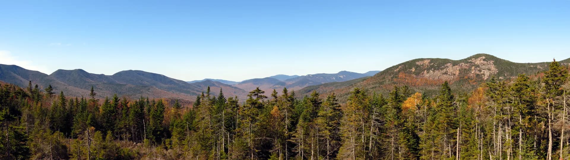
Fall (September through mid-October): The best time to visit if you can handle cooler temperatures. Fall foliage in the White Mountains is legendary, peaking from late September through the second week of October depending on elevation. The colors start high (above 3,000 feet) and work their way down. The Kancamagus Highway (Route 112) between Lincoln and Conway is one of the finest fall foliage drives in America, and it's free. Trails are less crowded after Labor Day. Temperatures drop: expect lows in the 20s and 30s at elevation. Some AMC huts transition to "self-service" mode in mid-September, which means lower prices but you provide your own food and sleeping bag.
Winter (November through April): The White Mountains in winter are serious business. Temperatures on Mount Washington regularly drop below minus 30 degrees Fahrenheit with wind chill, and the mountain holds the record for the highest wind speed ever directly measured at a surface weather station (231 mph in April 1934). That said, winter hiking here is a legitimate pursuit with a dedicated following. Snowshoes or crampons and microspikes are required on most trails above 2,500 feet. Avalanche danger exists in the ravines (Tuckerman, Huntington, and the Great Gulf). The AMC runs two huts in winter: Lonesome Lake Hut and Zealand Falls Hut, both on a caretaker basis. If you're new to winter hiking, start with lower-elevation trails and build up.
Spring (April through May): Mud season. The Forest Service asks hikers to avoid trails above 2,500 feet from mid-April through late May to prevent erosion during the thaw. Lower trails are muddy and buggy. It's the least popular season for good reason, but the waterfalls run at peak force.
Top Trails
The White Mountains have more quality hiking per square mile than anywhere else in the East. Here are four standout routes that cover a range of abilities and experiences.
Franconia Ridge Loop (8.6 miles, Strenuous)
This is it. The one hike in New England that belongs on every serious hiker's list. The loop starts at Lafayette Place Campground on I-93, climbs Falling Waters Trail past three waterfalls (Stairs Falls, Swiftwater Falls, Cloudland Falls), then emerges above treeline on Little Haystack Mountain at 4,760 feet. From there, the ridge walk north over Mount Lincoln (5,089 ft) and Mount Lafayette (5,260 ft) is roughly 1.7 miles of exposed, above-treeline hiking with views in every direction. The descent follows Old Bridle Path past Greenleaf Hut. Total elevation gain is about 3,900 feet. Plan 6 to 8 hours.
Mount Washington via Tuckerman Ravine (8.4 miles, Strenuous)
The classic route up the highest peak in the Northeast. The Tuckerman Ravine Trail starts at Pinkham Notch Visitor Center and climbs steadily through forest for 2.4 miles to the floor of Tuckerman Ravine, a glacial cirque famous for spring skiing. From the ravine, the trail ascends the headwall (steep, with rock scrambling in the upper section) and emerges on the summit cone. The summit has an observatory, a visitor center, and, frankly, a lot of tourists who drove or took the Cog Railway up. Don't let that diminish the accomplishment of hiking it. Round trip is 8.4 miles with 4,250 feet of gain. Budget 6 to 9 hours.
Arethusa Falls (2.8 miles, Easy to Moderate)
The tallest waterfall in New Hampshire at over 140 feet, and you can reach it on a 2.8-mile round-trip hike with only about 800 feet of elevation gain. The trail starts from a parking area on Route 302 in Crawford Notch State Park and follows Bemis Brook through mixed hardwood forest. The falls are most impressive in spring and early summer when snowmelt swells the flow, but they're worth the trip year-round. This is one of the best family-friendly hikes in the forest, and you can extend it by continuing to Frankenstein Cliff for views of Crawford Notch (adds about 3 miles round trip).
Mount Lafayette via Old Bridle Path (8.6 miles, Strenuous)
If you want to summit Lafayette without committing to the full Franconia Ridge Loop, Old Bridle Path is the direct route. The trail climbs 3,500 feet in 3.8 miles from Lafayette Place Campground to the summit, passing Greenleaf Hut (operated by the AMC) at about 2.5 miles. Above the hut, the trail breaks out of the trees and the final mile is an exposed scramble to the 5,260-foot summit. The views from the top stretch across the Pemigewasset Wilderness, over to the Presidential Range, and south to the lakes region. Return the same way, or if you've arranged a shuttle or have energy to spare, combine it with the full ridge traverse.
AMC Hut System
One of the things that makes the White Mountains unique is the Appalachian Mountain Club's system of eight backcountry huts, connected by trails and spaced roughly a day's hike apart. The huts offer bunk rooms, hot meals (breakfast and dinner), and composting toilets. You don't carry a tent, stove, or most of your food. You do carry your personal gear, sleeping bag liner, and snacks.
The huts, from west to east: Lonesome Lake, Greenleaf, Galehead, Zealand Falls, Mizpah Spring, Lakes of the Clouds, Madison Spring, and Carter Notch. Lakes of the Clouds, perched at 5,012 feet between Mount Monroe and Mount Washington, is the most dramatic and the most popular. Reservations are essential for summer weekends and should be made months in advance.
Full-service rates run roughly $155 to $175 per person per night, which includes dinner and breakfast. It's not cheap, but when you factor in the weight you're not carrying and the meals you're not cooking, many hikers find it worthwhile. The AMC also offers a "thru-hike" rate for hikers traversing multiple huts.
Campgrounds
The forest has over 20 developed campgrounds. Most are first-come, first-served, though several accept reservations through Recreation.gov.
Hancock Campground sits along the East Branch of the Pemigewasset River on the Kancamagus Highway. The 56 sites are shaded and well-spaced. It's a good base for hiking the Lincoln Woods Trail into the Pemigewasset Wilderness or driving the Kanc for foliage. Reservable, $25 per night.
Dolly Copp Campground is the largest in the forest with 176 sites near Pinkham Notch on Route 16. It's the most convenient base for Mount Washington and the Northern Presidentials. The campground sits at 1,500 feet elevation along the Peabody River. Sites are reservable, $25 per night. The best sites are along the river loops.
Sugarloaf I Campground is a smaller, 29-site campground off Route 302 in Twin Mountain. It's well-positioned for Zealand Falls Hut, the Sugarloaf Trail, Crawford Notch, and the Crawford Path (the oldest continuously maintained hiking trail in the country). Reservable, $25 per night.
Waterville Campground has 27 sites in Waterville Valley, a good base for Welch-Dickey Mountain and the Tripyramids. Reservable, $25 per night.
For backcountry camping, you can camp anywhere in the forest at least 200 feet from trails, water, and roads, as long as you're below treeline and outside of designated Forest Protection Areas (restricted zones around huts and popular areas). Check the WMNF website for a map of restricted areas before planning a backcountry trip.
Permits and Passes
WMNF Parking Pass: Required at most trailheads. A day pass costs $5, or you can buy an annual pass for $30. The Interagency Annual Pass ($80) and the America the Beautiful Senior Pass also work. You can buy passes at ranger stations in Campton, Bethlehem, and Gorham, at the Pinkham Notch Visitor Center, or online. Not having one will get you a ticket, typically $75 to $100.
No wilderness permit required. Unlike many western forests, the White Mountain National Forest does not require a free wilderness permit for day hikes or overnight trips. You do need to follow backcountry camping regulations (200 feet from trail, below treeline, not in Forest Protection Areas), but there's no registration or quota system. Our national forest camping permit guide explains how the White Mountains compare to forests like Deschutes or Inyo, where limited-entry permit lotteries are increasingly common.
AMC Hut Reservations: Not technically a permit, but effectively required for summer stays. Book through the AMC website or by calling their reservation line. Popular huts (Lakes of the Clouds, Greenleaf, Lonesome Lake) book out weeks to months in advance for summer weekends.
Getting There from Boston
The White Mountains are about 2.5 hours from downtown Boston, making them a realistic day trip (though an overnight is far better).
To Franconia Notch (western side): Take I-93 North from Boston straight to Lincoln and Franconia Notch State Park. The drive is 140 miles and takes about 2 hours and 15 minutes without traffic. I-93 through Franconia Notch narrows to a single lane in each direction, which can cause delays, especially during foliage season.
To Pinkham Notch (eastern side): Take I-95 North to Route 16 North through North Conway to Pinkham Notch. This is the gateway to Mount Washington and the eastern Presidentials. Roughly 160 miles, about 2.5 to 3 hours. You can also take Route 302 through Crawford Notch for a more scenic approach.
To the Kancamagus Highway: The Kanc runs 34.5 miles between Lincoln (I-93) and Conway (Route 16). There are no gas stations, services, or cell service along the highway. Fill up before you get on it. The Kanc is one of the best scenic drives in New England, but during peak foliage (late September through early October), it can be bumper-to-bumper on weekends. Midweek is significantly better.
Gas and supplies: North Conway is the main commercial hub for the eastern side, with grocery stores, outdoor shops (EMS, REI outlet, local gear shops), and restaurants. Lincoln serves the same purpose for the western side. Both towns have everything you need.
Weather: Respect the Mountains
The White Mountains produce weather that is genuinely dangerous, and the primary reason is Mount Washington. The summit sits at the intersection of three major storm tracks, and the topography funnels and accelerates winds through the Presidential Range. The result: summit temperatures average 27 degrees Fahrenheit annually, the summit is in cloud cover roughly 60 percent of the time, and hurricane-force winds (75 mph or greater) occur on average 110 days per year.
What this means for hikers: conditions at the trailhead bear little resemblance to conditions on the summit or along exposed ridges. You can start a hike in shorts and a t-shirt at 70 degrees and encounter 40-degree temperatures, 50 mph winds, and zero visibility above treeline. People die of hypothermia in the White Mountains in July.
Pack layers every time you go above treeline. At minimum: a synthetic or wool base layer, a fleece or insulated layer, a waterproof and windproof shell jacket and pants, hat, and gloves. This applies even on sunny days in July and August.
Check the Mount Washington Observatory forecast (mountwashington.org) before any above-treeline hike. The higher summits forecast is specific to the Presidential Range and Franconia Ridge. It includes wind speed, temperature, and visibility predictions that are far more useful than a general weather app.
Tips for Visitors
The 4,000-footer list is a thing. New Hampshire has 48 peaks over 4,000 feet, and "peakbagging" all 48 is a popular long-term goal. The AMC Four Thousand Footer Committee maintains the official list. Some peaks (like Owl's Head) are remote and trailless. Others (like Mount Tecumseh) are short and straightforward. It's a worthy pursuit if you want a framework for exploring the forest over many trips. Mount Chocorua, at 3,475 feet, doesn't make the list but is one of the most rewarding summit hikes in the forest.
Black flies and mosquitoes are fierce from late May through early July. The "bug season" in the White Mountains is legendary. A head net and permethrin-treated clothing are not overkill. By late July, the worst is over.
Moose are common, especially at dawn and dusk. The Kancamagus Highway, Route 16 north of Pinkham Notch, and Route 3 near Twin Mountain are all moose corridors. A collision with a moose is often fatal for both the moose and the driver. Slow down after dark.
Cell service is limited. You'll have coverage in the towns (North Conway, Lincoln, Gorham) and along major highways. On the trails, especially in the valleys and wilderness areas, expect nothing. Download maps and trail information before you go.
Start early. Afternoon thunderstorms are common in summer, especially above treeline. Plan to be off exposed ridges by early afternoon. Lightning above treeline is a serious threat with no place to shelter.
The Whites are steep. Unlike western mountains where trails often switchback gradually, trails in the White Mountains tend to go straight up. A trail gaining 3,500 feet in 3.8 miles (like Old Bridle Path) is not unusual. Your knees will know the difference. Trekking poles help enormously, especially on the descent.
Leave No Trace applies everywhere. The alpine zone above treeline is extremely fragile. Alpine plants grow only a fraction of an inch per year, and a single footstep off-trail can destroy decades of growth. Stay on the marked trail and walk on rock, not vegetation.
Bear awareness. Black bears are present in White Mountain National Forest, particularly at lower elevations. Follow proper food storage protocols when backcountry camping.
Comparing East and West. First-time visitors from the Rockies or Sierra often underestimate New England's peaks. For a useful overview of how national forest terrain and rules differ across regions, see our national forests vs. national parks guide. Hikers interested in exploring other Northeast national forests should note that the White Mountains have no close equivalent in New England, though George Washington and Jefferson National Forests in Virginia offer a similar Appalachian Trail experience with less severe weather.