Exploring Finger Lakes National Forest
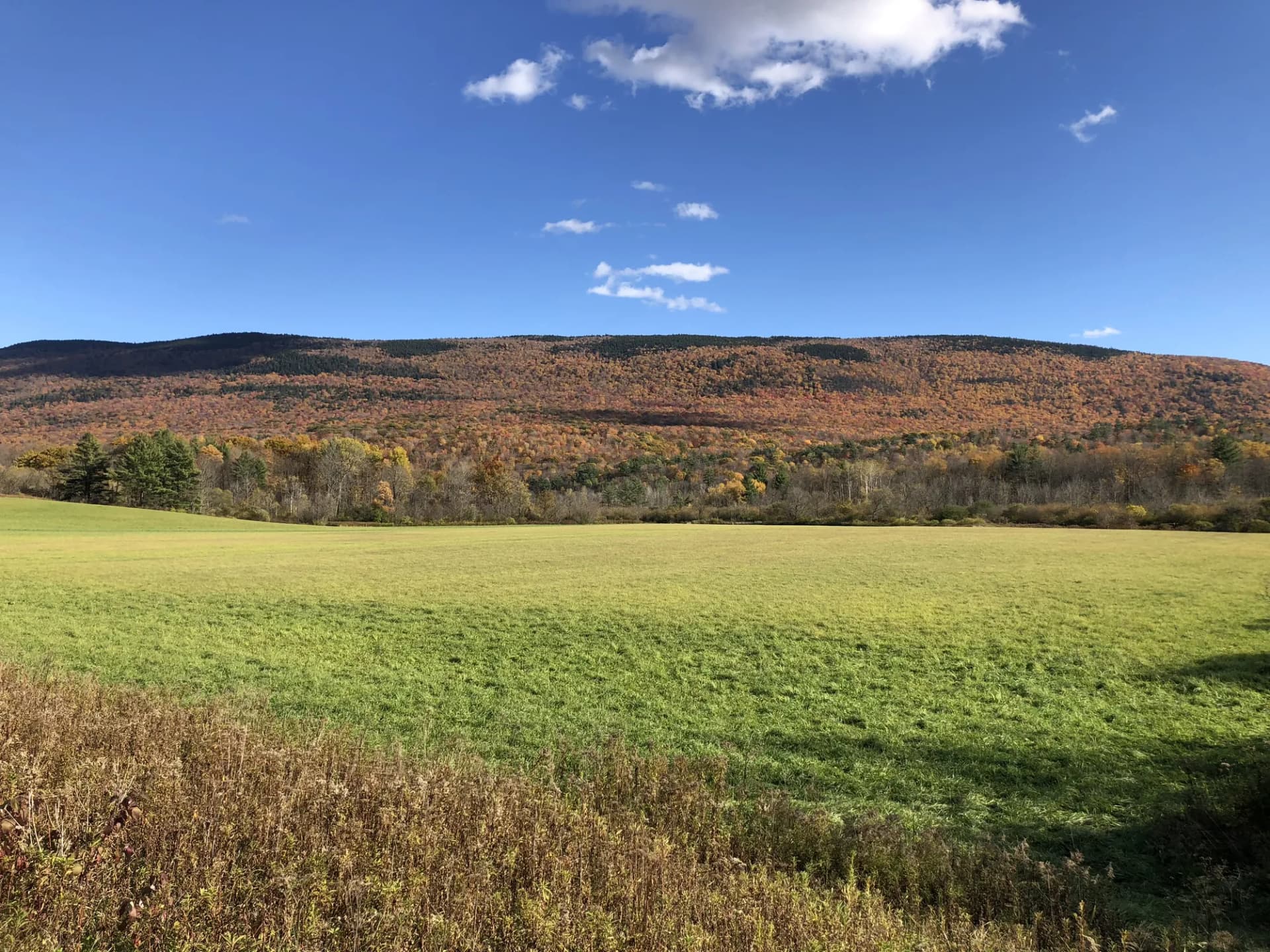
Finger Lakes National Forest occupies a 16,000-acre plateau ridge between Seneca and Cayuga Lakes in central New York, making it the only national forest in New York State and the smallest national forest in the Northeast. Established in 1985 from farmland the federal government purchased during the 1930s agricultural depression, it is a forest in ongoing transition: open grasslands and old fields exist alongside maturing hardwood stands, creating a patchwork landscape with a character distinctly different from older, larger national forests.
Honesty first: the trail system here is modest. With about 30 miles of hiking trail across 16,000 acres, Finger Lakes doesn't compete with the Adirondacks or the Catskills for trail variety. What it offers is different: a quiet ridge-top landscape above two of New York's most scenic glacial lakes, wild blueberry picking in summer, and easy access to a region packed with state parks and gorge hikes that far exceed the national forest itself in drama. Watkins Glen State Park is 10 miles away. Taughannock Falls State Park is 20 miles away. Finger Lakes National Forest works best as part of a larger regional itinerary.
Why Finger Lakes National Forest Stands Out
New York's Only National Forest
The status matters to some visitors. This is the only USDA Forest Service unit in all of New York State: a distinction that makes it worth knowing about even if it's not your primary destination. The federal land provides dispersed camping, horse trails, and hunting access that the surrounding state parks do not.
Blueberry Picking and Open Landscape
The forest's open grasslands: maintained through grazing leases and prescribed management: are covered with wild lowbush blueberries in summer. Mid-July through early August brings productive picking on the Blueberry Patch tracts and adjacent open areas. The landscape also provides habitat for bobolinks, meadowlarks, and other grassland birds that have become rare in the broader Northeast.
Gateway to the Finger Lakes Trail
The Finger Lakes Trail (FLT), a 950-mile multi-use trail system maintained by the Finger Lakes Trail Conference, passes through the national forest for several miles. The FLT connects Allegany State Park in western New York to the Catskills in the east. Segments within the national forest cross the ridge and connect to trailheads for longer through-hikes that extend well beyond the forest boundary. Understanding how the forest fits into the broader FLT network is key to planning a longer Finger Lakes region hiking trip. For context on how this compares to national park offerings, see our guide to national forests vs. national parks.
Best Trails
The trail system in Finger Lakes National Forest is small but covers the forest's highlights effectively.
The Gorge Trail is the most dramatic hike in the forest, following Gorge Creek through the forest's one significant canyon section on a 5.2-mile loop. The gorge is modest by Finger Lakes state park standards but interesting and often uncrowded.
The Blueberry Patch Trail is a short 1.8-mile loop through open grassland and forest edge with access to the wild blueberry picking areas. Best visited in July and August when berries are ripe.
The Finger Lakes Trail South Slope covers a 6.8-mile point-to-point segment of the FLT through the forest's southern portion, with glimpses of Seneca Lake from the ridge.
The Ravine Trail is a 2.4-mile out-and-back into a smaller ravine with seasonal stream flow, quieter than the Gorge Trail and accessible from a different trailhead.
The Interloken Trail is a 12-mile multi-use trail (the longest in the forest) that loops the central forest area and is shared with horses and mountain bikes. Day hikers typically cover a segment rather than the full circuit.
The North Ravine Trail accesses the northern side of the forest's main ridge with views toward Cayuga Lake through the tree canopy. 3.5 miles out-and-back.
The Backbone Trail follows the center spine of the forest plateau for 4.1 miles through open meadow and transitional hardwood. Good birding corridor in spring and summer.
The Southslope Trail is a 2.0-mile multi-use connector through the southern forest edge, used primarily by horseback riders but accessible on foot.
Permits and Passes
Day hiking and dispersed camping at Finger Lakes National Forest require no permits and no fees (as of 2026). The Blueberry Patch Campground is a first-come, first-served primitive campground with a nominal $5/night fee (as of 2026): no advance reservation.
The Potomac Group Campground accommodates organized groups and requires a reservation and nightly fee through Recreation.gov (as of 2026). The America the Beautiful Annual Pass is accepted for applicable day-use fees. Veterans and active-duty military qualify for free passes: see our veteran benefits guide for details.
Camping
Blueberry Patch Campground is a primitive, 10-site first-come, first-served campground with vault toilets and no water. Sites are in a mix of open grassland and forest edge near the blueberry picking areas. Open April through November (as of 2026), $5/night (as of 2026).
Potomac Group Campground accommodates organized groups with 12 reservable sites, drinking water, and vault toilets. Open May through October (as of 2026). Book through Recreation.gov.
Dispersed camping is permitted throughout the forest following Leave No Trace guidelines. The open grassland sections and forest edge areas near the ridge are popular spots.
When to Visit
May and June bring spring wildflowers and bird migration. Bobolinks and meadowlarks display in the grasslands. Trails are green but can be muddy in early May.
July and August are blueberry season: the primary reason many people specifically visit the national forest rather than the adjacent state parks. The open ridge is hot in midday; morning visits are most comfortable.
September and October offer the best hiking conditions: cool temperatures, fall foliage, and negligible bugs. The ridge maple and oak turn brilliant colors in mid-October.
Winter provides snowshoeing and cross-country skiing on the flat ridge sections. The open grasslands accumulate snow that holds well. No groomed trails.
Getting There
From Watkins Glen: Watkins Glen is 10 miles west of the forest on NY-414 and is the main gateway town. The state park at Watkins Glen is one of the most visited in New York and combines naturally with a forest visit for a full day in the region.
From Ithaca: Ithaca is 30 miles southeast on NY-96 and is home to Cornell University and multiple gorge trails within the city and surrounding area. The drive through the Finger Lakes wine region adds scenic value.
From Hector: The small hamlet of Hector sits practically inside the forest. Forest Road 1 (Burnt Hill Road) runs through the forest interior from Hector and provides access to most trailheads.
Practical Tips
The Finger Lakes region is wine country, and the national forest plateau is surrounded by vineyard roads. A visit to the forest pairs naturally with a wine trail afternoon: the forest itself typically takes a half-day rather than a full day for most hikers given its compact trail network.
Check conditions before visiting, especially during spring mud season (April through early May). Forest roads can be soft and impassable to low-clearance vehicles. The checking conditions before you go guide covers the key USFS resources.
Practice Leave No Trace principles throughout your visit, particularly in the open grassland areas where soil compaction from off-trail walking can be significant.