Tahoe National Forest covers approximately 850,000 acres of California's northern Sierra Nevada, stretching from the American River canyon in the south to the Feather River country in the north. The forest is a patchwork: federal land intermixed in a checkerboard pattern with private holdings, the legacy of 19th-century railroad land grants. Within those public acres, you'll find granite peaks, glacial lake basins, old-growth fir forests, and the rushing forks of the Yuba and American rivers. The forest headquarters sits in Nevada City at 631 Coyote Street, roughly 60 miles east of Sacramento, but the terrain you're actually visiting lies another 30 to 50 miles up into the mountains.
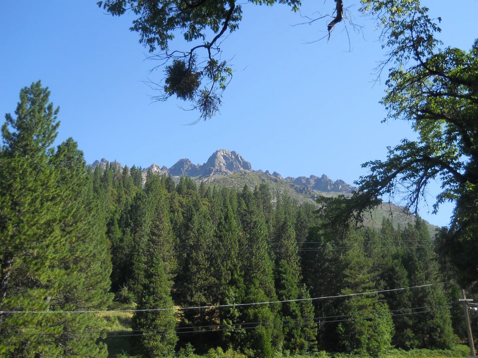
The northern Sierra Nevada here is different from the southern range. The peaks are lower than the Mt. Whitney country, the snowpack is deep and reliable, and the landscape feels more intimate. The Sierra Buttes rise to 8,587 feet above the Lakes Basin like a broken tooth, visible for 100 miles on clear days. The Granite Chief Wilderness sits directly above the Palisades Tahoe ski area, a fact that tells you something about the character of this place: serious terrain right next to commercial recreation. If you come expecting solitude, you'll find it. If you come expecting accessible, rewarding day hikes within two hours of a major metro area, you'll find that too.
Getting There
From Sacramento: Take I-80 east toward Truckee. The freeway cuts through the heart of the forest, crossing Donner Summit at 7,056 feet. Most trailheads on the western slope are accessed via exits along I-80 between Auburn (mile marker 80) and Truckee (mile marker 185). The Sierra Buttes area requires leaving I-80 at Highway 49 south of Truckee, then continuing north through Downieville toward Sierra City. Allow 1.5 to 2 hours from Sacramento to reach most western-slope trailheads, and closer to 2.5 hours for the Sierra City area.
From Reno: Take I-80 west over Donner Summit. Truckee is about 30 miles west of Reno, and the Donner Summit trailheads are another 12 miles beyond that. The Five Lakes and Granite Chief trailheads near Alpine Meadows Road are about 45 minutes from downtown Reno. Reno is the eastern gateway for anyone approaching from Nevada.
Highway 49 is the spine of the western portion of the forest, connecting the historic Gold Rush towns of Nevada City, Grass Valley, and Downieville. Many of the best trailheads in the Sierra Buttes and Gold Lakes Basin areas are accessed via Forest Service roads off Highway 49. Some of these roads are paved; others are graded dirt requiring a high-clearance vehicle in dry conditions.
Top Trails
Tahoe National Forest offers trails across the full range of difficulty, from easy lake loops to sustained summit climbs.
The Sierra Buttes Lookout is the signature hike of the northern Sierra. The 5-mile out-and-back from the Packer Lake trailhead climbs 1,571 feet to an operational fire lookout at 8,587 feet, accessed via a vertiginous series of steel ladders bolted to the final cliff. The 360-degree views take in Sardine Lake, Packer Lake, the Sacramento Valley, and on clear days, Mount Shasta 100 miles north.
The Five Lakes trail starts at Alpine Meadows Road near Palisades Tahoe and climbs 1,089 feet in 4.6 miles to a cluster of lakes at the edge of the Granite Chief Wilderness. Almost all of the elevation gain comes in the first mile, which is steep enough to discourage casual visitors. The lakes themselves are calm, clear, and relatively crowd-free compared to easily accessed alternatives.
Loch Leven Lakes is the most popular moderate hike along the I-80 corridor. The 7.5-mile round trip from the Big Bend Visitor Center trailhead gains 1,538 feet through pine and granite terrain to reach three alpine lakes between 6,800 and 6,900 feet. It's an excellent choice for hikers who want alpine scenery without committing to a full-day push.
Granite Chief is the hardest trail in the Granite Chief Wilderness and the best way to earn the view from the 9,019-foot summit. The 6.8-mile route from the Olympic Valley trailhead gains nearly 2,000 feet on a trail that connects to the Pacific Crest Trail near the summit. On a clear day you can see both Lake Tahoe to the east and the Sacramento Valley to the west.
Grouse Ridge takes you to a 1923 lookout tower at 7,707 feet above the Gold Lakes Basin. The 10.1-mile loop from the Grouse Ridge trailhead passes Milk Lake, Island Lake, Long Lake, and Glacier Lake, with consistent views throughout. This is the best full-day hike in the northern section of the forest.
The Round Lake trail from Carr Lake provides the easiest route into the Gold Lakes Basin. The 4.5-mile round trip gains only 500 feet and passes through rolling granite terrain past Feely Lake and Island Lake before reaching Round Lake at 7,000 feet. Dogs are welcome and the trail is suitable for fit beginners.
Castle Peak rises to 9,103 feet above Donner Summit and is reached via a 6-mile round trip that follows the PCT for part of its route. The trail starts at the Boreal I-80 interchange, making it the most accessible summit hike in the forest. The final approach involves some exposure on Class 2 terrain.
Palisade Creek is the backcountry route of the eight. The 12.7-mile out-and-back (or overnight) follows the North Fork American River from French Meadows Reservoir into a remote canyon draining the Granite Chief Wilderness. Elevation gain is 2,585 feet. This trail sees a fraction of the traffic that the lakes-area routes attract.
Camping
Tahoe National Forest has more than 60 developed campgrounds scattered across five ranger districts. Three solid options cover different parts of the forest.
Salmon Creek Campground sits near Sierra City on the main highway 49 corridor, making it the most convenient base camp for the Sierra Buttes and Gold Lakes Basin. The 31 sites are reservable through Recreation.gov at around $24 per night as of early 2026 — verify current fees before booking. Sites have picnic tables and fire rings. The campground is adjacent to the North Yuba River, and the sound of running water carries through the trees.
East Meadow Campground is one of nine campgrounds clustered around Jackson Meadows Reservoir in the northern reaches of the forest. The 46 sites are reservable at around $24 per night as of early 2026 — verify current fees at Recreation.gov. Open June through October. Jackson Meadows sits at about 6,100 feet and offers boat ramp access, fishing for rainbow and brown trout, and a quieter character than the I-80 corridor campgrounds. It's the best choice for an extended camp-based trip.
Woodcamp Campground is also on Jackson Meadows Reservoir, with 10 sites at around $24 per night from June through September as of early 2026 — verify current fees at Recreation.gov. It's smaller and more intimate than East Meadow, with direct lake access. Woodcamp is reservable through Recreation.gov.
For dispersed camping, the forest allows camping outside designated campgrounds on most National Forest lands, provided you camp at least 200 feet from water, trails, and roads, and pack out everything you bring in. A free California Campfire Permit is required for any fire or stove outside a developed campground. During high fire danger periods (typically July through October), open fires are prohibited and sometimes stoves as well. Check current restrictions at the Tahoe National Forest website before your trip.
Permits and Fees
Tahoe National Forest does not require the Adventure Pass that covers Southern California forests. Most trailhead parking is free. The main permit you need to know about is the California Campfire Permit, required any time you use a camp stove or build a fire outside a developed campground. Get it free at preventwildfireca.org before leaving home.
Developed campgrounds charge nightly fees, generally $20 to $30 per site as of early 2026 — verify current fees at Recreation.gov before booking. Recreation.gov handles reservations for most campgrounds, and sites fill weeks ahead on summer weekends for popular locations like Jackson Meadows. Book early.
The Interagency Annual Pass and Senior Lifetime Pass cover fees at some specific day-use sites and developed recreation areas within the forest. Neither is required for the primary trailhead areas, but both are worth having if you visit multiple federal recreation areas annually. Veterans and active military should check eligibility for the Military Annual Pass through Recreation.gov.
For Leave No Trace principles in the backcountry, no permit is currently required for overnight use of the Granite Chief Wilderness. Self-registration boxes are present at some trailheads. Check the forest website for any permit changes before your trip, as the USFS has added permit requirements to high-use wilderness areas across the country in recent years.
Wildlife and Ecology
The forest spans a significant elevation range, from about 1,500 feet in the American River foothills to over 9,000 feet in the Granite Chief Wilderness. That range produces distinct ecological zones stacked on the Sierra Nevada's western slope.
Lower elevations (below 4,000 feet) host blue oak woodland and chaparral, transitioning to mixed conifer forest of ponderosa pine, white fir, and incense cedar in the middle elevations. Above 6,500 feet, the forest shifts to red fir and lodgepole pine, giving way to subalpine terrain of whitebark pine and exposed granite above 8,000 feet.
Mammals: Black bears are present throughout the forest. They are particularly active in late summer and fall when they're packing on calories before winter, and human food attractants are the primary driver of problem encounters. Use bear boxes at developed campgrounds and hang food or use a bear canister in the backcountry. Mule deer are common; they migrate to lower elevations in winter and return to alpine meadows by summer. Mountain lions inhabit the forest but are rarely encountered. Smaller mammals include black-tailed jackrabbits, marmots (in the rocky subalpine zone), and pikas at the highest elevations.
Birds: The forest supports breeding populations of spotted owls in old-growth stands and bald eagles around the larger lakes. Osprey nest near Jackson Meadows Reservoir and other fishable lakes. At lower elevations, acorn woodpeckers are conspicuous and loud; they cache acorns in "granary trees" riddled with thousands of holes. Steller's jays are the camp robber equivalent here, bold and persistent at any site with food visible.
Fish: The Yuba River's three forks (North, Middle, South) and the American River drainages support significant trout populations. Rainbow and brown trout are the primary species. Salmon Creek, the creek, is named for historical salmon runs that no longer occur this far upstream due to dam construction on the lower rivers. Sardine Lake and Gold Lake are popular destinations for family fishing, both stocked regularly.
Best Time to Visit
Spring (April through May): The lower elevation foothills are green and flowering, and the rivers run high with snowmelt. Most mountain trailheads are still snow-covered, but the I-80 corridor trails below 5,500 feet are accessible by May. Expect mud and stream crossings on trails transitioning from winter.
Early Summer (June through July): Snow clears from most trails by mid-June, though the Sierra Buttes and Granite Chief routes may hold snow on north-facing slopes through late June. Wildflowers are excellent in the Gold Lakes Basin by mid-July, particularly around Round Lake and the Grouse Ridge cirque. Mosquitoes are heavy through late June, especially at lake elevations.
High Summer (August through early September): The prime window. Trails are clear, afternoon thunderstorms are possible but typically brief, and the lakes warm enough for swimming. Crowds are at their peak at the most accessible trailheads (Five Lakes, Loch Leven Lakes). Book campground sites months in advance for August weekends.
Fall (September through October): The best season for solitude and color. Aspens in the valleys and willows at lake margins turn yellow and orange by late September. Temperatures cool, crowds thin, and the afternoon thunderstorm pattern fades. Trails are open until the first significant snowfall, which typically arrives in October or November.
Winter (November through May): The mountains are under several feet of snow. Palisades Tahoe, Boreal Mountain, and Donner Ski Ranch operate as downhill ski areas. Cross-country skiing and snowshoeing are good throughout the forest, particularly on groomed tracks at Royal Gorge and Tahoe Donner Cross Country ski areas. Sno-Park permits are required for winter recreation parking at designated sno-park sites.
Tips for Your Visit
Download maps before leaving cell service. Cell coverage is poor on most forest roads and nonexistent at backcountry trailheads. The USFS Avenza PDF map for Tahoe NF is free to download. AllTrails offline maps are worth downloading for specific trails. Do not rely on in-car navigation past the main highways.
Get a campfire permit before you leave. The California Campfire Permit is required for any fire or stove outside a developed campground. The five-minute online process at preventwildfireca.org saves you from a citation and keeps you legal. During periods of elevated fire danger, even stoves may be restricted.
The checkerboard ownership pattern matters. Tahoe National Forest is not a contiguous block of public land. Some roads and trailheads cross private property. Stay on designated routes and respect posted no-trespassing signs. The Motorist Map available at ranger stations shows public versus private land.
Afternoon thunderstorms are common July through August. Plan to be at or below treeline before early afternoon on summer days. Granite Chief and Sierra Buttes summits are exposed and attract lightning. Start early and turn around if you see anvil clouds building to the west.
Bear safety is not optional. Black bears in this forest associate humans with food. Use the provided bear boxes at developed campgrounds, and use a bear canister for any overnight trip in the backcountry. A fed bear is eventually a dead bear.
Check road conditions before driving to trailheads. Many forest roads are unpaved, and some require high-clearance vehicles. The Bowman Lake Road to the Grouse Ridge area is particularly rough in places. Roads to the Sierra Buttes area above Sierra City can close with early-season snow. Call the Nevada City or Truckee ranger district offices for current conditions.
Fishing licenses are required. California requires a fishing license for anyone 16 and older. Annual licenses are available at sporting goods stores in Truckee, Nevada City, and Grass Valley, as well as online through the California Department of Fish and Wildlife.
For more information on planning overnight trips, the national forest camping permit guide covers logistics for backcountry camping across the country's national forests.