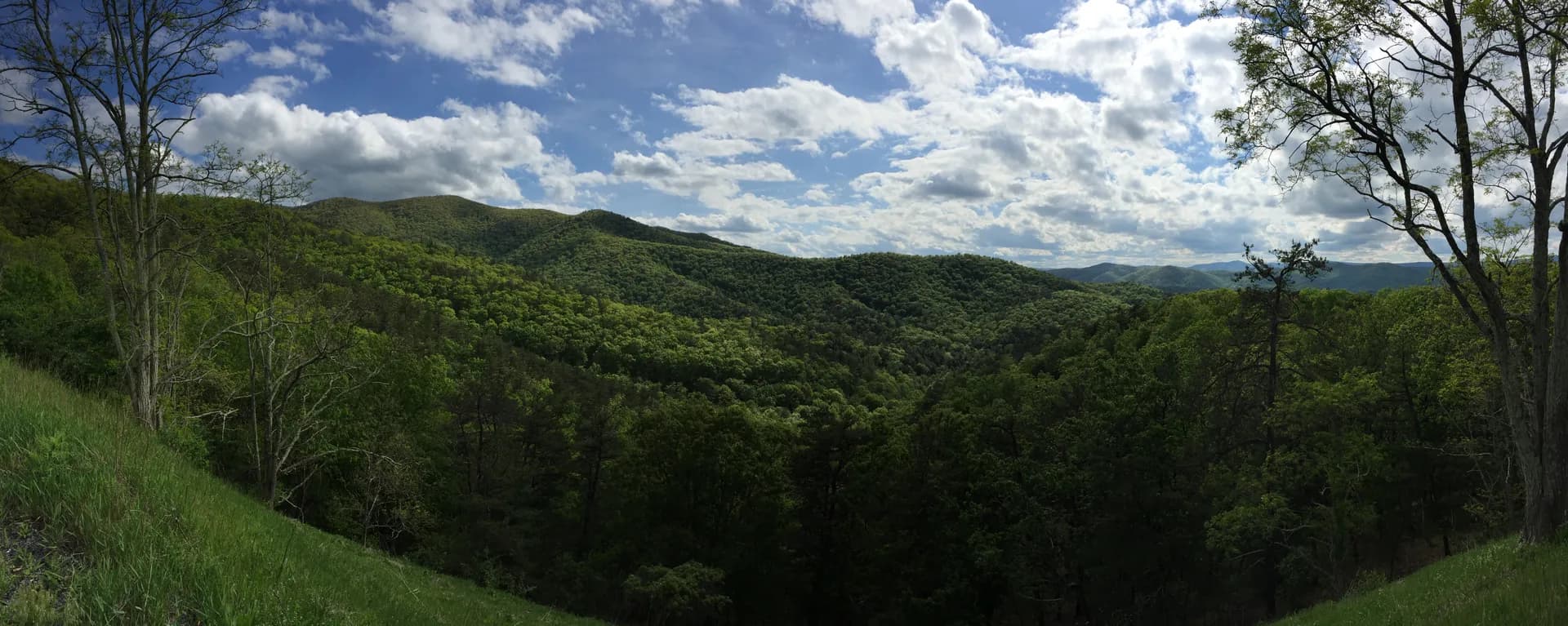
Chattahoochee-Oconee National Forests cover nearly 866,000 acres across northern Georgia, split into two distinct units. Unlike nearby Great Smoky Mountains National Park, national forests like the Chattahoochee operate under a multiple-use model that allows hunting, dispersed camping, and open access to most trailheads at no charge. Our national forests vs. national parks guide explains the key differences. The Chattahoochee division sprawls across the Blue Ridge Mountains in the northeast corner of the state, a landscape of steep ridges, deep hollows, and cold mountain streams that feels nothing like the Georgia most people picture. The Oconee division sits further south in the Piedmont, covering rolling hardwood forest between Athens and Macon. Together, they make up the largest public land holding in Georgia and one of the most important outdoor recreation areas in the Southeast.
For most visitors, the Chattahoochee side is the draw. This is where the Appalachian Trail begins (or ends, depending on your direction), where Georgia's tallest peaks break 4,000 feet (including Brasstown Bald, the state's highest point at 4,784 feet), and where waterfalls pour off every mountainside after a good rain. It is also, critically, only 90 minutes from Atlanta. That proximity makes the Chattahoochee one of the most heavily used national forests in the country, but the trail system is extensive enough that you can find solitude if you know where to look.
Why Chattahoochee-Oconee Stands Out
The southern terminus of the Appalachian Trail. Springer Mountain, at 3,782 feet, marks the start of the 2,190-mile Appalachian Trail to Mount Katahdin in Maine. Every year, thousands of thru-hikers take their first steps here in March and April, and the Approach Trail from Amicalola Falls State Park has become a pilgrimage in its own right. Even if you have no intention of hiking to Maine, standing at the bronze plaque on Springer's summit and looking north into the endless ridgelines of the southern Appalachians is a powerful experience. The 8.1-mile Approach Trail from Amicalola Falls is one of the toughest starts to any long-distance trail in the country, gaining over 3,000 feet and descending steeply to cross Nimblewill Gap before climbing again to the summit.
Atlanta's mountain escape. No major American city has a national forest this close. The drive from Midtown Atlanta to Dahlonega takes about 90 minutes, and from Dahlonega you're at a trailhead within 10 more. On Friday afternoons, the northbound lanes of GA-400 fill with city dwellers heading to the mountains. The towns of Dahlonega, Helen, and Blue Ridge have built entire tourism economies around their proximity to the forest. Dahlonega, the site of America's first gold rush in 1828, is the most practical base for accessing trails in the southern part of the forest. Helen, a Bavarian-themed village that draws mixed reactions, sits directly adjacent to the forest's eastern section and provides the closest access to Anna Ruby Falls and the upper Chattahoochee River.
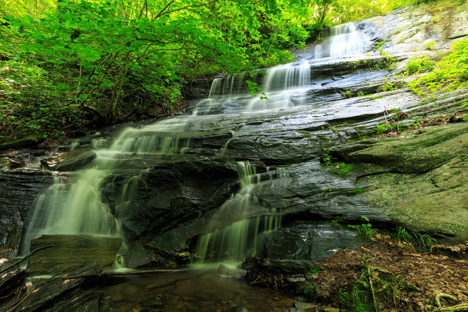
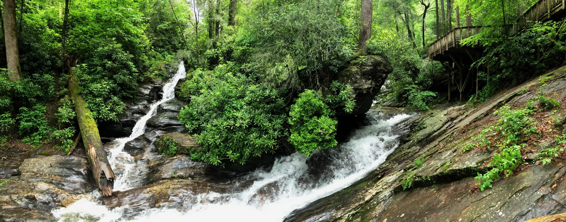
Waterfall country. The combination of high annual rainfall (60 to 80 inches in the mountains), ancient metamorphic rock, and thousands of feet of elevation change produces waterfalls everywhere. Anna Ruby Falls is the most developed and accessible: a double waterfall where Curtis Creek drops 153 feet and York Creek drops 50 feet, meeting at the base. Raven Cliff Falls is more dramatic, a 100-foot cascade that splits and pours through a massive cleft in the rock face, visible from a wooden observation platform at the end of a 2.5-mile hike. DeSoto Falls, Helton Creek Falls, Dukes Creek Falls, Panther Creek Falls, and Amicalola Falls (at 729 feet, the tallest waterfall in the Southeast, technically in the adjacent state park) round out a waterfall circuit that could fill an entire weekend.
Best Trails in Chattahoochee-Oconee
With over 850 miles of trails, including about 80 miles of the Appalachian Trail in Georgia, the Chattahoochee side of the forest offers everything from paved nature walks to multi-day backpacking routes. Here are four of the best.
Blood Mountain via Appalachian Trail
The most popular day hike in the Georgia mountains, and for good reason. This 4.6-mile out-and-back from the Byron Reece Trailhead climbs 1,500 feet to the summit of Blood Mountain at 4,458 feet, the highest point on the Appalachian Trail in Georgia. The trail is well-maintained and well-signed, but it is not easy: the final half-mile is a rocky scramble over exposed boulders. At the summit, you'll find a historic stone shelter built by the Civilian Conservation Corps in the 1930s and panoramic views of the Blue Ridge stretching into North Carolina. On clear days, visibility reaches 80 miles or more. The trailhead parking lot fills by 9 AM on fall weekends. Arrive early or hike on a weekday.
Raven Cliff Falls
A 5-mile out-and-back that follows Dodd Creek through a rhododendron-lined gorge to one of Georgia's most impressive waterfalls. The trail gains about 750 feet over 2.5 miles, most of it gradual, and ends at a wooden observation deck facing Raven Cliff Falls. The falls are unusual: the water doesn't simply drop over a ledge but flows through a massive cleft in the rock face, splitting and recombining as it descends about 100 feet. In spring and after heavy rain, the volume is spectacular. The trailhead is on Richard Russell Scenic Highway (GA-348), one of the most scenic drives in the state. This is an excellent half-day hike for all ability levels.
Springer Mountain via AT Approach Trail
The Approach Trail from Amicalola Falls State Park to the southern terminus of the Appalachian Trail is 8.1 miles one way (16.2 miles out-and-back), with approximately 3,000 feet of elevation gain. This is not a casual day hike. The trail starts by climbing 604 steel steps alongside Amicalola Falls, then follows a rugged footpath through dense hardwood forest, descending to Nimblewill Gap before climbing again to Springer Mountain's summit at 3,782 feet. Most people do this as an overnight, camping at the Springer Mountain shelter or the nearby Black Gap shelter. If you're doing it as a day hike, start at dawn and carry plenty of water, as reliable water sources are limited along the ridgeline. The bronze plaque at the summit marks the official start (or finish) of the 2,190-mile Appalachian Trail.
Anna Ruby Falls
The shortest and easiest hike on this list, but one of the most rewarding. A 0.8-mile out-and-back on a paved, wheelchair-accessible trail leads from the visitor center to the base of Anna Ruby Falls, where two creeks (Curtis Creek and York Creek) tumble off the side of Tray Mountain and converge. Curtis Creek Falls drops 153 feet and York Creek Falls drops 50 feet, side by side. The setting is lush, shaded by hemlock and rhododendron, and the falls are impressive in any season. A $5 per person day use fee is charged at the entrance. The parking area is about 1 mile up a paved road from the entrance station. This is the best option in the forest for anyone with limited mobility, families with small children, or anyone who simply wants a beautiful waterfall without a strenuous hike.
Permits and Passes
The Chattahoochee-Oconee is relatively easy on the wallet compared to many western national forests.
Day use at most trailheads: Free. You can park and hike at the vast majority of trailheads in the forest without paying a fee. This includes the Byron Reece Trailhead (Blood Mountain), the Raven Cliff Falls Trailhead, and most Appalachian Trail access points.
Developed recreation areas: A $5 per day parking fee is required at some developed sites, including picnic areas, swimming beaches, and certain campground day-use areas. These fees are posted at each site.
Anna Ruby Falls: $5 per person (not per vehicle). Children 15 and under are free. The fee is collected at the entrance station and covers parking and trail access. The America the Beautiful Interagency Pass ($80/year) is accepted.
Backcountry camping: Free. No permit is required for backcountry camping anywhere in the Chattahoochee National Forest. Camp at least 200 feet from trails and water sources, use a camp stove or existing fire ring, and follow Leave No Trace principles. Our guide on how to get a national forest camping permit covers the broader national system, which is useful context even when a specific forest doesn't require one.
Campfire regulations: The forest occasionally issues burn bans during dry periods, particularly in late summer and fall. Check the Chattahoochee-Oconee National Forests website or call the Blue Ridge Ranger District (706-745-6928) for current conditions before building any campfire.
Camping
The Chattahoochee offers several developed campgrounds in the mountains, all of them relatively small and affordable compared to campgrounds in national parks.
DeSoto Falls Campground has 24 sites along Frogtown Creek, near the DeSoto Falls Scenic Area on US-129. Sites are $16 per night and reservable through Recreation.gov. The campground is shaded, quiet, and within a short drive of Blood Mountain, Vogel State Park, and the DeSoto Falls trail system. This is a good central base for exploring the southern Chattahoochee.
Lake Winfield Scott Campground sits on the shore of a small mountain lake at 2,900 feet, with 32 sites at $18 per night. Reservable through Recreation.gov. The campground has flush toilets, a swimming beach, and a 0.6-mile loop trail around the lake. From here, it's a short drive to the Slaughter Creek Trailhead for Blood Mountain or to the Sosebee Cove Scenic Area, one of the best wildflower displays in Georgia.
Dockery Lake Campground is a small, rustic option with 11 sites at $10 per night, first-come-first-served. The campground is on the shore of Dockery Lake, a 6-acre trout-stocked lake at 2,400 feet. The Dockery Lake Trail connects to the Appalachian Trail, making this a good staging point for AT day hikes or section hikes. Vault toilets, no showers.
Andrews Cove Campground has 10 sites at $10 per night, first-come-first-served. It sits along Andrews Creek in a sheltered cove near the Unicoi Gap section of the Appalachian Trail. Small, quiet, and rarely full outside of peak weekends. Vault toilets, no showers.
For dispersed camping, the Chattahoochee offers extensive options along the Appalachian Trail corridor and throughout the backcountry. Popular areas include the ridgeline between Blood Mountain and Springer Mountain, the Tray Mountain Wilderness, and the Cohutta Wilderness in the northwest corner of the forest. The Cohutta, in particular, is one of the largest wilderness areas in the eastern United States and sees relatively few visitors compared to the AT corridor. The Rich Mountain Loop is one of the best trails in this area.
When to Visit
March through May: Spring comes early to the Georgia mountains, and it's beautiful. Wildflowers (trillium, bloodroot, flame azalea, mountain laurel) bloom from March through May, starting in the valleys and working uphill. Waterfalls are at peak volume. The Appalachian Trail corridor is busy with thru-hikers heading north, which gives the shelters and campsites a social, energetic atmosphere. Temperatures in the mountains range from the 50s to the 70s. Rain is frequent. Bring layers and a rain jacket.
June through August: Summer in the north Georgia mountains is warm and humid. Valley temperatures regularly hit the mid-80s to low 90s, and the humidity can be oppressive on south-facing slopes. Higher elevations (above 3,500 feet) are noticeably cooler, with temperatures in the 70s and occasional breezes. Afternoon thunderstorms are common, sometimes intense, and usually roll through between 2 PM and 5 PM. Start hikes early. Despite the heat, summer is a fine time to visit if you choose your trails wisely: shaded creek-side hikes like Raven Cliff Falls and Anna Ruby Falls are comfortable even on the hottest days. Swimming holes along the Chattahoochee River and its tributaries offer relief.
September and October: The best time to visit. September brings lower humidity, comfortable temperatures (60s to 70s during the day), and dramatically thinner crowds. October is fall color season, and the Georgia mountains deliver: sugar maples, sourwood, hickory, and tulip poplars turn brilliant shades of red, orange, and gold. Color typically peaks in the third and fourth weeks of October at elevations above 3,000 feet, working its way downhill through early November. Blood Mountain and the Richard Russell Scenic Highway are two of the best spots for fall foliage in the state.
November through February: The forest is open year-round. Lower elevation trails are hikeable throughout winter, though higher ridgelines can see ice, snow, and bitter winds. Temperatures on Blood Mountain's summit can drop into the teens. Winter hiking in the Chattahoochee is quiet and rewarding if you're prepared, but the campgrounds are closed and water sources may be frozen. Dahlonega and Helen make good winter bases, with warm restaurants and lodging close to the trailheads.
Getting There
From Atlanta: Take GA-400 north to Dahlonega (about 90 minutes in normal traffic, 2 hours or more on Friday afternoons). From Dahlonega, US-19 north leads to the Byron Reece Trailhead (Blood Mountain) in about 30 minutes. GA-60 and US-129 connect to other trailheads in the southern Chattahoochee. For Helen and the eastern section of the forest, take GA-400 to GA-115 to GA-75 north (about 2 hours total).
From Helen: Anna Ruby Falls is 6 miles north of Helen via GA-356. The Chattahoochee River headwaters, Unicoi State Park, and the upper section of the Appalachian Trail near Unicoi Gap are all within a 20-minute drive.
From Amicalola Falls State Park: The park, home to the AT Approach Trail and the 729-foot Amicalola Falls, is about 18 miles west of Dahlonega via GA-52. The park charges an $5 per vehicle parking fee (Georgia State Parks pass also accepted).
Hartsfield-Jackson Atlanta International Airport (ATL) is the closest major airport, about 100 miles south. The drive to Dahlonega takes about 2 hours, depending on Atlanta traffic. Rental cars are available at the airport. There is no public transit to the forest.
Practical Tips
Heat and humidity. This is the biggest challenge for summer visitors. The combination of high temperatures, high humidity, and steep trails can be dangerous. Drink more water than you think you need (a minimum of 1 liter per hour on strenuous summer hikes), take breaks in shade, and start early. Heat exhaustion is a real risk on exposed climbs like Blood Mountain in July and August.
Water treatment. Streams and springs are abundant in the Chattahoochee, but treat all water before drinking. Giardia and other waterborne pathogens are present in Georgia's mountain streams, even in clear, fast-flowing water at high elevation. A filter, chemical treatment (Aquamira, iodine), or UV purifier (SteriPen) all work. Do not drink untreated water from any source in the forest.
Hunting season. Georgia's deer hunting season runs from mid-September through mid-January, with the firearms season typically starting in late October. During firearms season, wear blaze orange if you're hiking off the Appalachian Trail (the AT corridor itself is closed to hunting). Specific season dates and regulations are published annually by the Georgia Department of Natural Resources. The forest is open to hunting in most areas outside of developed recreation sites.
Black bears and food storage. The north Georgia mountains have an active black bear population. Use bear-resistant containers or hang food bags at least 200 feet from camp. See our guide on bear canister requirements for specifics on wilderness food storage.
Ticks and insects. Ticks are active from March through November and are common in the understory at lower elevations. Lone star ticks, in particular, are aggressive and abundant in the Georgia mountains. Check yourself thoroughly after every hike. Apply permethrin to clothing and use DEET or picaridin on exposed skin. Mosquitoes are present near standing water but are generally manageable.
Road conditions. US-19, US-129, and the major state highways through the forest are paved and well-maintained. Forest roads vary from good gravel to rough, rutted tracks. Most trailheads are accessible by standard passenger vehicles, but a few (particularly in the Cohutta Wilderness area) require high-clearance vehicles. Check conditions with the ranger district before heading down an unfamiliar forest road.
Cell service. Coverage is spotty throughout the mountain section of the forest. You'll have a signal in Dahlonega, Helen, and Blue Ridge, and along the major highways. Once you're on a trail or a forest road, expect to lose it. Download offline maps (Google Maps, Gaia GPS, or AllTrails) before your trip.
The Oconee side. The Oconee National Forest, south of Athens, is a different landscape entirely: rolling Piedmont hills, pine and hardwood forest, and the shores of Lake Sinclair and Lake Oconee. It is primarily used for hunting, fishing, horseback riding, and mountain biking. The Oconee River corridor and the Scull Shoals Historic Area (ruins of a 19th-century industrial village) are worth a visit if you're in the area, but the mountain trails of the Chattahoochee are what draw most visitors to this forest.
The Bottom Line
Chattahoochee-Oconee National Forests are Georgia's great outdoor asset. The Chattahoochee side, in particular, packs a surprising amount of mountain terrain, waterfall scenery, and Appalachian Trail heritage into a forest that sits less than two hours from the largest city in the Southeast. Blood Mountain is worth the climb. Raven Cliff Falls is worth the walk. Standing on Springer Mountain and contemplating the 2,190 miles of trail stretching north to Maine is worth the effort. Start in Dahlonega, work your way up US-19 to the AT trailheads, and then loop over to Helen for the waterfalls. Hikers wanting to continue along the Appalachian Trail corridor should look north to the George Washington and Jefferson National Forests in Virginia, or west to Pisgah National Forest near Asheville in North Carolina, where the AT passes through equally dramatic mountain terrain. The forest rewards anyone willing to get off the highway and onto the trail.