George Washington and Jefferson National Forests stretch across 1.8 million acres of the Appalachian Mountains in Virginia, West Virginia, and a small corner of Kentucky. Unlike national parks with their entrance fees and tight permit systems, national forests like the GW&J operate on a very different set of rules, with free dispersed camping, no trailhead permits, and open hunting in most areas. Administratively combined since 1995, this is the largest block of public land in the eastern United States and the backbone of outdoor recreation in the central Appalachians. If you hike, camp, fish, or hunt anywhere in Virginia, odds are you've spent time here.
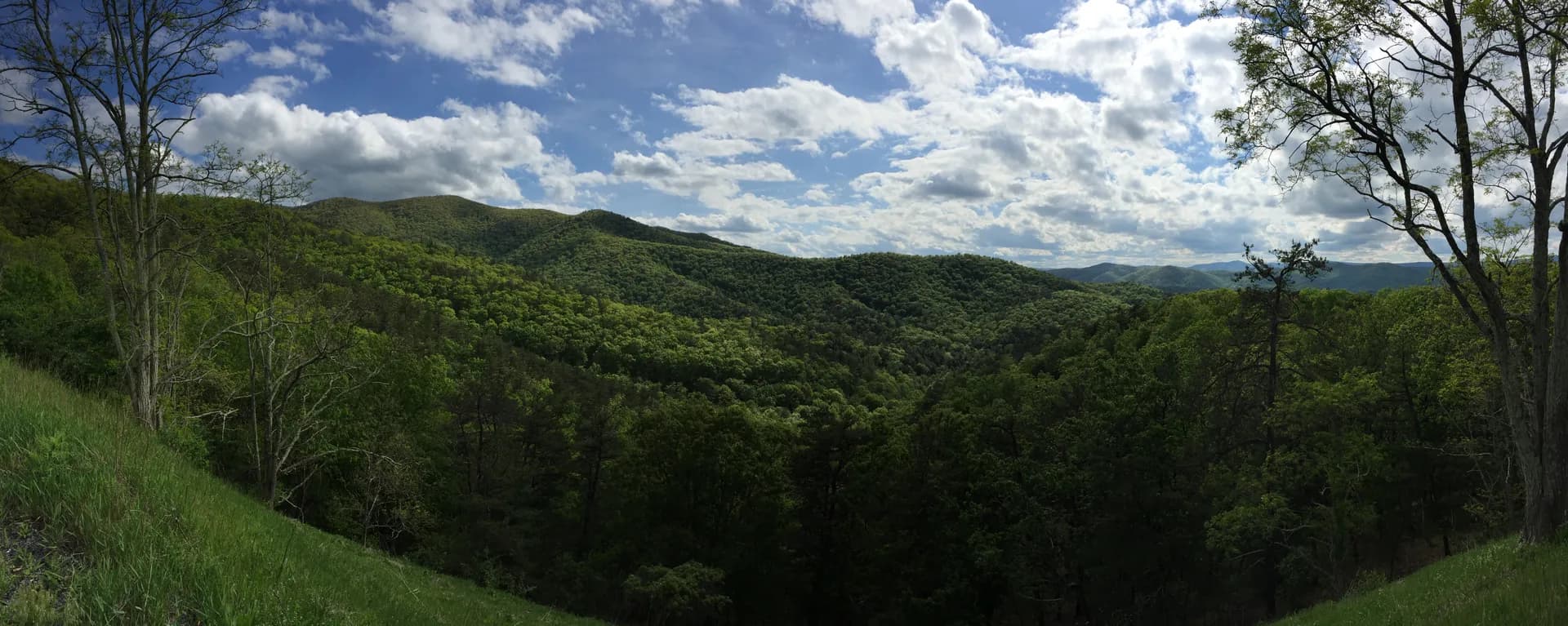
The forest runs roughly 340 miles along the spine of the Blue Ridge and Allegheny Mountains, from the James River in the south to the Potomac River near the West Virginia border in the north (for the George Washington side) and down through the southern Virginia highlands to the Tennessee border (for the Jefferson side). Within those boundaries are over 2,000 miles of trails, including 330 miles of the Appalachian Trail. That AT mileage alone makes this one of the most important trail corridors in the country.
What sets these forests apart from other eastern national forests is the combination of accessibility and scale. Roanoke, a city of 100,000 people, sits right against the forest boundary. McAfee Knob, the most photographed point on the entire AT, is a 15-minute drive from downtown. You can eat breakfast at a Roanoke coffee shop, bag one of the best ridge hikes on the East Coast, and be back for a late lunch. That kind of access to serious mountain terrain is rare east of the Rockies.
Why These Forests Matter
Three features define the character of George Washington and Jefferson National Forests.
The Appalachian Trail corridor. With 330 miles of the AT passing through, this is the longest stretch of the trail within any single national forest. The most famous sections are the Triple Crown: McAfee Knob, Tinker Cliffs, and Dragon's Tooth. Thru-hikers consider this one of the most scenic stretches in Virginia, and weekend hikers from DC, Richmond, and Roanoke treat these trails as their home turf.
The southern highlands and Mount Rogers. The Jefferson National Forest's southern section includes Mount Rogers (5,729 feet), Virginia's highest peak, neighboring Whitetop Mountain (5,520 feet), and the Grayson Highlands, where wild ponies graze in open alpine meadows that feel more like Scotland than the American South. The Mount Rogers area has over 400 miles of trails, including the Virginia Highlands Horse Trail and the AT, and it's one of the few places in the Southeast where you can hike above treeline.
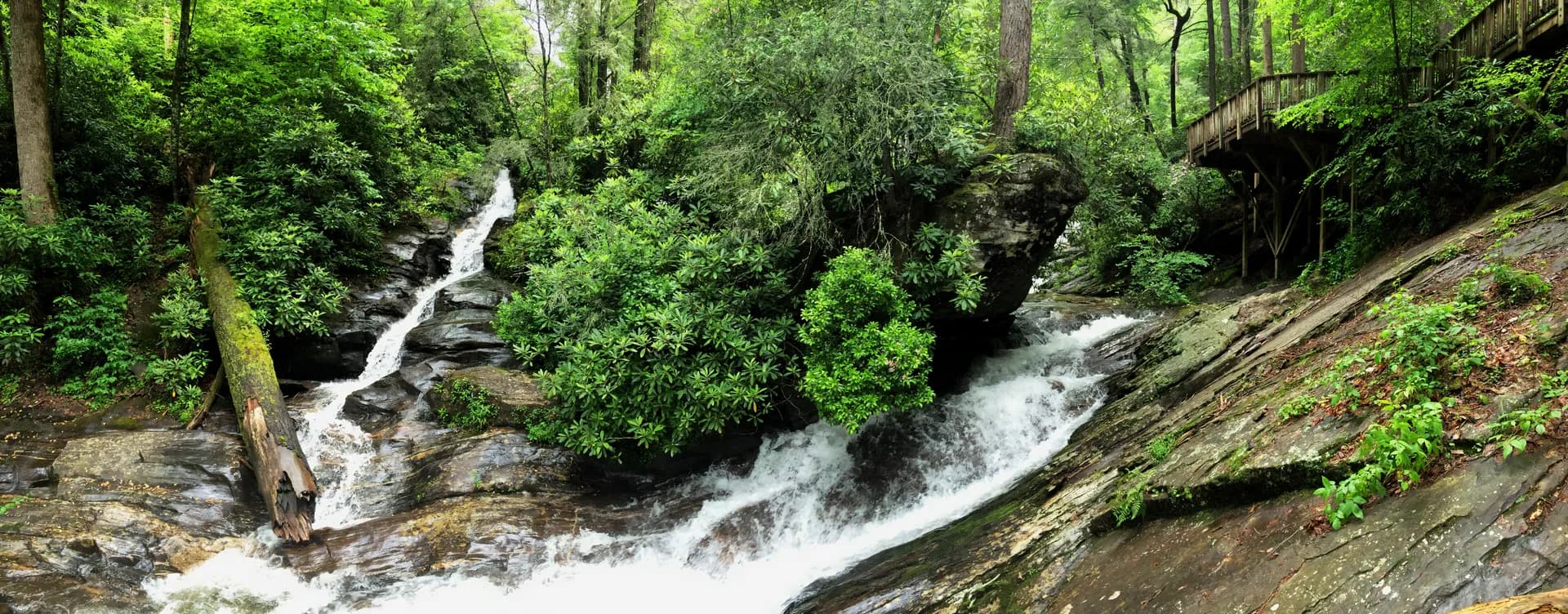
Waterfalls and geology. The Blue Ridge escarpment on the eastern edge of the forest produces some of the tallest waterfalls in the East. Crabtree Falls drops over 1,200 feet across five cascades, making it the tallest cascading waterfall east of the Mississippi. The limestone geology of the Allegheny side has carved out hundreds of caves, sinkholes, and springs, including Natural Bridge (now a state park but historically part of the forest's story).
Top Trails
The forest has over 2,000 miles of trails ranging from easy streamside strolls to rock-top viewpoints like Chimney Rock and strenuous ridge traverses. Here are four of the best.
McAfee Knob (8.8 miles, Moderate)
The most photographed spot on the Appalachian Trail, and it earns it. The 8.8-mile out-and-back climbs 1,720 feet to a dramatic sandstone ledge overlooking the Catawba Valley, with views stretching to the Allegheny Mountains on a clear day. The rock outcrop is the one you've seen in every AT photo: a flat ledge jutting out over a 1,000-foot drop where hikers sit with their legs dangling. It's dramatic, a little terrifying, and absolutely worth the climb. Spring and fall weekends draw crowds, so start early.
Crabtree Falls (3.4 miles, Moderate)
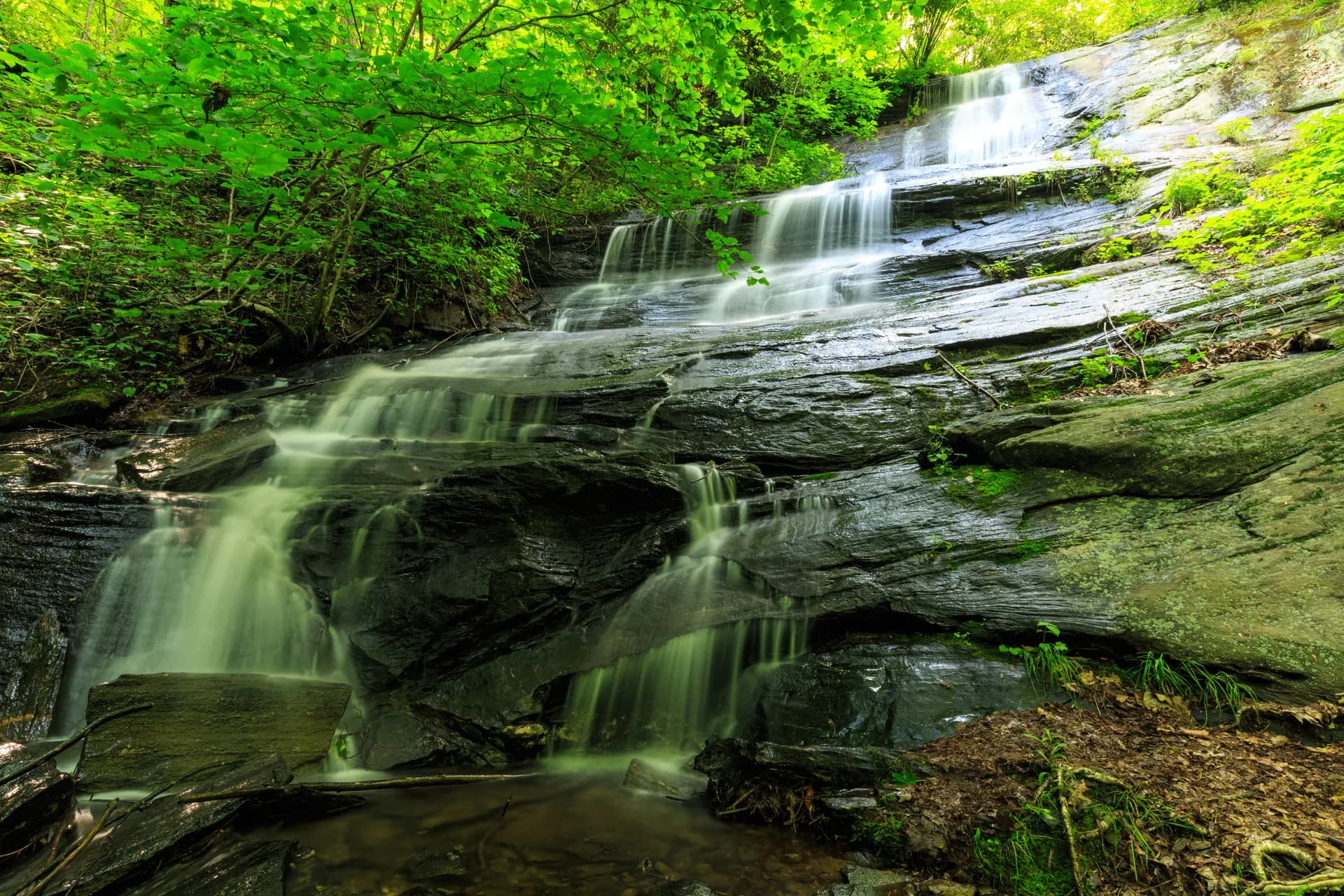
The tallest cascading waterfall east of the Mississippi, dropping over 1,200 feet across five major cascades along Crabtree Creek. The 3.4-mile out-and-back trail climbs 1,500 feet alongside the falls, with multiple viewing platforms at each cascade. The lower falls are the most dramatic, but the upper cascades offer more solitude. This trail is deceptively steep for its short distance. Stay behind the guardrails: Crabtree Falls has claimed more than 30 lives from falls, making it one of the most dangerous trails in Virginia for those who leave the path.
Dragon's Tooth (4.6 miles, Moderate to Hard)
Virginia's most dramatic rock scramble. The 4.6-mile out-and-back climbs 1,600 feet to a massive quartzite spire on the Cove Mountain ridge. The final approach involves Class 3 rock scrambling with some exposed moves. The "tooth" itself is a 35-foot rock tower that you can stand on top of for 360-degree views. Not recommended for dogs (the scrambling sections are too steep and exposed) or anyone with a serious fear of heights. Pair it with McAfee Knob for a legendary day if you have the legs.
Humpback Rocks (2 miles, Moderate)
A short, sharp climb to one of the best panoramic views on the Blue Ridge Parkway. The 2-mile out-and-back gains 800 feet in just 1 mile, so expect to work. The reward is a collection of massive rock outcrops with 360-degree views of the Blue Ridge and Shenandoah Valley. It's one of the most popular sunrise hikes in Virginia. The trailhead sits right off the Blue Ridge Parkway near milepost 6, and the adjacent Humpback Rocks Mountain Farm is a restored 19th-century homestead worth exploring after your hike.
Campgrounds
The forest has dozens of developed campgrounds and virtually unlimited dispersed camping opportunities along forest roads. Here are four developed options worth knowing.
North Creek Campground is a small, quiet campground with 15 sites along North Creek, about 15 miles north of the Blue Ridge Parkway on Route 614. Sites are $12 per night and reservable through Recreation.gov. The creek offers decent native trout fishing, and the Apple Orchard Falls Trail (a 2.6-mile out-and-back to a 150-foot waterfall) starts nearby. Open April through November.
Cave Mountain Lake Campground sits at 2,400 feet elevation on a 7-acre lake in the James River Ranger District. The 42 sites run $16 per night and are reservable. The lake has a small swimming beach, and several trails connect to the campground, including a short loop around the lake. It's a good family base camp with flush toilets and warm showers. Open April through October.
Sherando Lake Campground is the largest and most developed option, with 68 sites at $20 per night on a scenic 25-acre lake in the Blue Ridge Mountains. The lake has a sand beach, swimming area, and non-motorized boat access. Sites are reservable and fill quickly on summer weekends. Two loops of the campground sit on the lakeshore, and the Blue Loop Trail (a 7.2-mile loop) climbs to views from the surrounding ridges. Open April through October.
Todd Lake Campground is a small, first-come-first-served campground with 20 sites at $10 per night near a 7.5-acre lake in the North River area. The lake is stocked with trout, and the campground serves as a jumping-off point for trails in the Ramseys Draft Wilderness. No reservations accepted, which means you might score a site when everything else is booked. Open May through October.
Permits and Passes
One of the best things about George Washington and Jefferson National Forests: most recreation is free.
Day hiking: No permits or passes are required for hiking on any trail in the forest. Unlike many western national forests, there are no trailhead parking fees and no wilderness permits. Just show up and walk.
Camping: Dispersed camping is free and allowed throughout the forest, as long as you're at least 300 feet from any trail, road, body of water, or developed recreation area. This is a huge advantage over western forests with limited backcountry permits. You can car camp along forest roads or backpack deep into the wilderness without filling out a single form.
Developed campgrounds charge fees ranging from $10 to $20 per night, depending on the facility. Some accept reservations through Recreation.gov, while others are first-come, first-served.
Hunting and fishing: Virginia and West Virginia hunting and fishing licenses are required. The forest is extremely popular for deer, turkey, and bear hunting in season. If you're hiking during fall hunting season (October through January), wear blaze orange.
Seasonal Guide
Spring (April through May): Wildflower season in the Appalachians is spectacular, and these forests are ground zero. Trillium, Virginia bluebells, wild azaleas, and mountain laurel bloom in waves from the valleys up to the ridgelines. Dogwoods peak in mid-April at lower elevations. Waterfalls run at their highest volume. The weather is unpredictable: 70 degrees and sunny one day, 40 degrees and sleeting the next. Bring layers. Ticks become active in April, so start checking yourself after every hike.
Summer (June through August): Hot and humid in the valleys (highs in the 85-95 range), but the ridges at 3,000 to 4,000 feet are noticeably cooler. Afternoon thunderstorms are common and can be severe, particularly along exposed ridgelines like McAfee Knob and Dragon's Tooth. Plan to be off high ground by early afternoon. Swimming holes along mountain streams become prime destinations. The Grayson Highlands and Mount Rogers area stays comfortable even in midsummer, with highs in the low 70s.
Fall (September through November): Peak season. Fall color in these mountains rivals anything in New England, with the added advantage of fewer crowds. Color moves from the highest elevations (Mount Rogers turns in mid-September) down to the valleys (peak color in the Roanoke area is typically the third week of October). McAfee Knob at sunset during fall color is one of the finest experiences available on the East Coast. Hunting season begins, so wear orange if you're in the backcountry after mid-October.
Winter (December through March): The forest stays open year-round, though many campgrounds close and some forest roads become impassable. Snowfall is variable: the ridges above 3,000 feet may see 2 to 4 feet of total accumulation in a normal winter, while the valleys often see bare ground. Trails like McAfee Knob and Humpback Rocks are hikeable year-round, but you'll want microspikes for ice. Winter solitude in these mountains is something special: you might not see another person all day on trails that see hundreds in October.
Getting There
From Roanoke: You're already here. McAfee Knob trailhead (Route 311) is 15 minutes from downtown. Dragon's Tooth trailhead is 30 minutes. The forest boundary touches the city's western and northern edges. Roanoke has a regional airport (ROA) with direct flights to major East Coast hubs, plus hotels, restaurants, and gear shops. It's the best base for the Triple Crown trails.
From Washington, DC: Take I-66 West to I-81 South. The northern edge of the George Washington National Forest is about 2 hours from DC (near Harrisonburg). McAfee Knob is about 3.5 hours. The Blue Ridge Parkway runs through the forest for about 60 miles and makes an excellent scenic driving route. Weekend warriors from DC should plan on the Staunton/Lexington area for the northern forest or Roanoke for the central section.
From Richmond: Take I-64 West. Humpback Rocks and Crabtree Falls are about 2 hours from downtown Richmond. Both sit right along the Blue Ridge Parkway and make excellent day trips.
From Charlotte, NC: Take I-77 North to I-81 North. The Mount Rogers area and Grayson Highlands are about 3 hours. Roanoke and the Triple Crown are about 3.5 hours.
Practical Tips
Ticks are a real concern. The forests of Virginia are prime habitat for deer ticks (black-legged ticks), which carry Lyme disease, as well as lone star ticks and dog ticks. Tuck your pants into your socks, use permethrin-treated clothing, apply DEET to exposed skin, and do a thorough tick check after every hike. The risk is highest from April through August, but ticks are active year-round in mild winters.
Thunderstorm awareness saves lives. Afternoon thunderstorms are common from May through September, and the exposed ridgelines of the AT (McAfee Knob, Dragon's Tooth, Tinker Cliffs) are no place to be when lightning is striking. Check the forecast before you hike, and plan to be below treeline by early afternoon. If you hear thunder, descend immediately.
Hunting season changes the equation. These forests are some of the most popular hunting lands in the Mid-Atlantic. General firearms deer season in Virginia runs from mid-November through early January, and bear season overlaps. During this period, wear blaze orange on any trail in the forest, not just off-trail areas. Sundays are closed to hunting in Virginia, making them the safest days for hikers during the season.
Water is plentiful but treat it. Mountain streams run throughout the forest, and backcountry water sources are generally reliable even in late summer. Giardia is present, so filter or treat all water. Springs are your best bet for clean backcountry water, and there are hundreds of mapped springs throughout the forest.
Dispersed camping is legal and free, but do it right. Camp at least 300 feet from trails, roads, and water. Use existing fire rings where available. Respect fire bans during dry periods (typically late summer and fall). Pack out all trash. The freedom to camp anywhere in the forest is a privilege worth protecting.
Black bears are common. The forest supports one of the densest black bear populations in the eastern United States. Use bear canisters or hang food bags at least 200 feet from your campsite when backcountry camping. Bears in this forest are generally shy, but they will investigate unattended food. Keep a clean camp and you'll have no problems.
Cell service is unreliable. Major ridgelines near Roanoke sometimes get a signal, but once you're in the valleys or deeper into the forest, expect no coverage. Download your maps, tell someone your itinerary, and plan accordingly. Roanoke and the I-81 corridor have full service. Everything else is a gamble.
Blue Ridge Parkway access. The Parkway runs through the forest for about 60 miles and provides access to several trailheads, including Humpback Rocks and trails near Peaks of Otter. The Parkway has a 45 mph speed limit and no commercial traffic, making it a pleasant (if slow) way to move between trailheads. Sections may close in winter due to ice and snow. Hikers who follow the Blue Ridge south will eventually reach Pisgah National Forest near Asheville, NC, where the Parkway continues through equally spectacular mountain terrain. Practice Leave No Trace principles throughout both forests, especially on the heavily used AT corridor.