William B. Bankhead National Forest covers 181,000 acres of the Cumberland Plateau in northwest Alabama, a landscape of sandstone-capped tablelands cut by deep creek canyons where waterfalls drop from overhanging bluffs into clear cold pools. At the heart of the forest is the Sipsey Wilderness, 25,988 acres of the most dramatic canyon country in the state, protecting the Sipsey Fork of the Black Warrior River and its tributaries in a landscape that required genuine effort to designate and even more effort to preserve through subsequent decades.
The Bankhead is an underrated destination by any southeastern measure. Its canyon trails in the Sipsey Wilderness rival anything in the southern Appalachians for scenery, and the botanical richness of its cove forests and canyon bottoms is extraordinary. Spring wildflower season from late March through mid-April brings thousands of visitors who might never otherwise set foot in an Alabama national forest, and they consistently express surprise at the quality of what they find.
Why Bankhead Stands Out
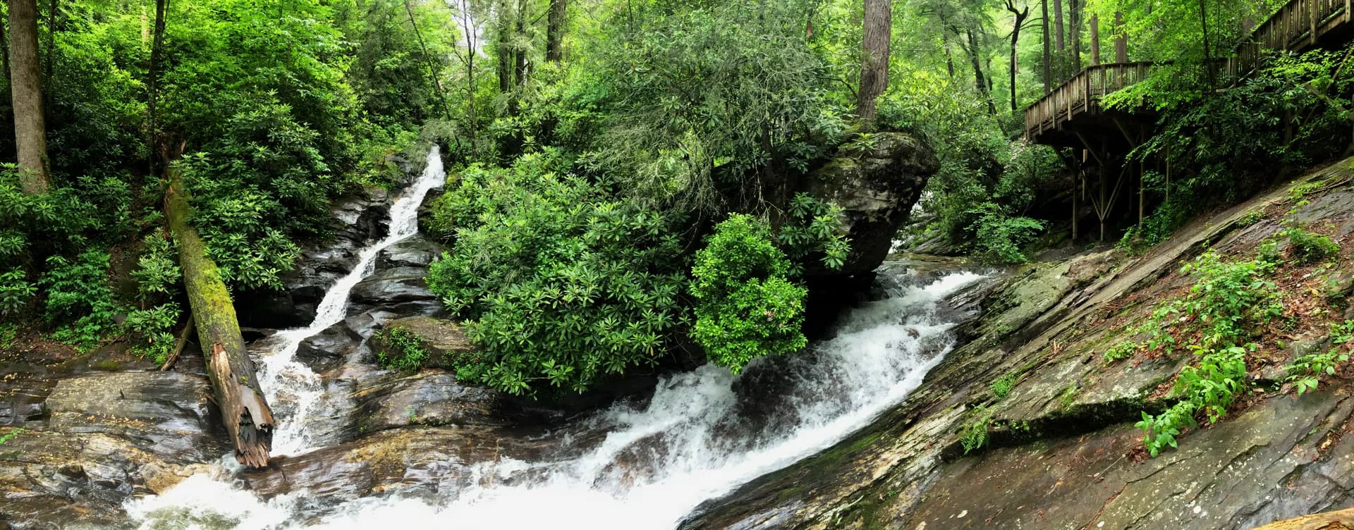
Sipsey Wilderness canyon country. The core of the Bankhead experience is the canyon system carved by the Sipsey Fork and its tributary Bee Branch into the Cumberland Plateau sandstone. The canyons reach depths of 100 to 200 feet in places, with overhanging bluffs that create sheltered amphitheater walls and dramatic waterfalls in wet weather. Old-growth hemlock and tulip poplar grow in the canyon bottoms, protected by the difficult terrain from the logging that transformed the surrounding plateau in the early 20th century. The Sipsey Fork Loop and Bee Branch Scenic Trail access the best of this terrain.
Botanical diversity. The Bankhead and Sipsey Wilderness are recognized as one of the most botanically diverse areas in the eastern United States, with a flora reflecting the meeting of multiple regional plant communities. The sandstone substrate, the range of microhabitats from wet canyon bottoms to dry plateau surfaces, and the protection afforded by the wilderness designation have preserved a flora that includes significant numbers of rare and endemic plant species. Spring ephemerals are the most celebrated, but the diversity extends through all seasons.
The Sipsey Fork river. The Sipsey Fork of the Black Warrior River is the longest free-flowing (undammed) river remaining in Alabama, protected within the wilderness boundary from the reservoir development that has transformed most of the state's river systems. The fork is cold, clear, and supports wild populations of native fish. It is one of the finest small trout streams in the southeastern United States, and its corridor provides the ecological backbone for the wilderness.
Best Trails
The Sipsey Fork Loop (9 miles, moderate) is the defining hike of the Bankhead, combining canyon bottom and rim trail for a full circuit through the wilderness's most scenic terrain. The Bee Branch Scenic Trail (4.5 miles, moderate) covers the most dramatic waterfall and bluff scenery in the forest.
The Sipsey River Picnic Area Trail (2.5 miles, easy) is the most accessible option, starting at the popular picnic area with immediate river access. The Natural Bridge Loop (3 miles, easy-moderate) visits one of the geological highlights of the plateau.
The Wolf Pen Hunter Camp Trail (5 miles, moderate) explores the plateau terrain east of the wilderness. The Clear Creek Trail (6 miles, moderate) follows another canyon stream through undeveloped terrain. The Brushy Lake Trail (3.5 miles, easy) circles a small lake near a campground. The Thompson Creek Trail (7 miles, moderate-hard) is the most challenging rim-and-canyon route in the forest.
Permits and Passes
No permit is required for day hiking or dispersed camping in Bankhead National Forest. Developed campground sites require a fee and reservations through Recreation.gov during peak season (as of 2026). The America the Beautiful pass covers day use fees at developed recreation areas. Veterans and active military have additional options in our veteran benefits guide.
Fire restrictions may apply during dry fall periods. Check current conditions at the USFS Alabama website or our checking conditions guide.
Camping
Corinth Campground (64 sites) is near Smith Lake in the southern forest, with a lake swimming area, boat ramp, and easy access to the Water Turkey Bay hiking area. Reservations available through Recreation.gov; popular on summer weekends.
Clear Creek Campground (103 sites) is the largest campground in the forest, near Smith Lake with water access. A good choice for families wanting a lake-based experience.
Houston South Campground (80 sites) is near the Sipsey Wilderness trailheads, making it the best base for hikers targeting the canyon trails. Open year-round with basic facilities.
Dispersed camping is permitted throughout the national forest and in the Sipsey Wilderness. The wilderness allows camping throughout; camps should be at least 200 feet from water and the trail. The canyon bottom is popular for dispersed camping on weekend backpack trips.
When to Visit
March and April are the peak season. Spring wildflowers draw significant crowds, particularly on weekends in late March and early April. Waterfalls are fullest after winter rains. Temperatures in the canyon bottoms are pleasant (50s to 60s), but the plateau can be cool. Book campground sites well in advance for spring weekends.
May through August bring summer heat and humidity. The canyon bottoms stay cooler than the plateau surface, making canyon trails the best warm-weather option. Swimming holes in the Sipsey Fork are popular in summer.
September and October are excellent for hiking. The humidity drops, temperatures moderate, and the forest begins its fall color transition in mid-October. One of the most rewarding seasons for canyon hiking.
November through February: Hikeable in good weather, with bare trees opening winter views from the rim trails. The forest is quiet and the canyon has a different, more dramatic quality in the low winter light.
Getting There
From Birmingham: Take I-65 north to I-22 west toward Double Springs. The Bankhead Ranger District office is in Double Springs on US-278. Allow about 1.25 hours from Birmingham.
From Tuscaloosa: Take US-43 north to US-278 east toward Double Springs. Allow about 1 hour.
From Huntsville: Take US-72 west to US-278 west toward Double Springs. Allow about 1.5 hours.
Practical Tips
Copperheads and timber rattlesnakes are present in the forest, particularly on rocky terrain and in rocky outcrops near the canyon rims. Follow USFS guidance: stay on trail in rocky areas, watch where you step and place your hands, and give any snake you encounter ample space.
Flash flooding is a risk in the canyon bottoms during heavy rain events. The narrow canyon walls can concentrate rainfall rapidly. Check weather forecasts before canyon hiking, and do not camp in the canyon bottom when rain is expected.
Ticks are common from March through October. Apply insect repellent and do thorough checks after hiking in brushy terrain.
Leave no trace principles are particularly important in the Sipsey Wilderness, where the canyon bottoms show increasing visitor pressure. The Leave No Trace seven principles cover campfire management (fires in fire rings only), waste disposal, and minimizing impact at popular swimming and camping spots. Review our checking conditions guide for trail and river conditions.