The Lolo National Forest
The Lolo National Forest is the backyard wilderness of Missoula, Montana, a 2.2-million-acre forest that begins at the edge of the city and extends north, west, and south in every direction. Few American cities have this kind of direct wilderness access, and Missoula's outdoor culture reflects it: on any weekday morning, Rattlesnake Creek Trail sees runners, mountain bikers, and hikers from a city that treats the national forest as a collective front yard.
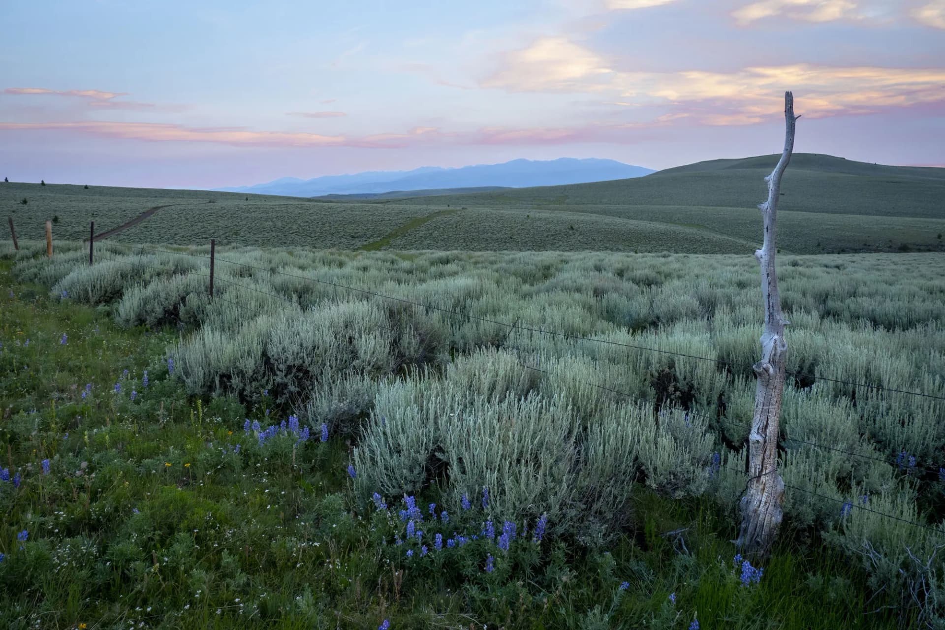
Beyond the urban-adjacent recreation around Missoula, the Lolo is a forest of genuine wildness. It holds portions of two wilderness areas, blue-ribbon trout waters on the Blackfoot and Clark Fork rivers, and the historic Lolo Trail corridor traveled by the Lewis and Clark Expedition in September 1805. The forest's geographic position between the Northern Rockies and the Clark Fork basin gives it a diverse set of ecosystems, from ponderosa grassland savannas at lower elevations to subalpine fir and alpine terrain on the highest ridges.
Why Lolo National Forest Stands Out
The Rattlesnake Wilderness and Urban Access
The Rattlesnake Wilderness, designated in 1980, sits within walking distance of Missoula's residential neighborhoods. The 33,000-acre wilderness is small by Montana standards but provides a remarkably pure wilderness experience given its proximity. Rattlesnake Creek runs clear and cold through the wilderness, supporting a native cutthroat population that is one of the healthiest in the Clark Fork drainage. The surrounding National Recreation Area adds trail mileage open to mountain bikes and horses, creating a layered recreation system that accommodates multiple user groups.
The Historic Lolo Trail Corridor
In 1805, the Lewis and Clark Expedition crossed the Continental Divide via Lolo Pass and descended into the Bitterroot Valley on a route now formalized as the Lolo Trail. The forest manages this corridor and maintains interpretive sites along the historic route. US Highway 12 follows the general path of the expedition, and the historic Lolo Motorway, a rough dirt road along the Bitterroot Mountains ridge above the highway, offers a more immersive connection to the route. The Nez Perce people traveled this corridor for centuries before the expedition.
Clark Fork and Blackfoot River Fishing
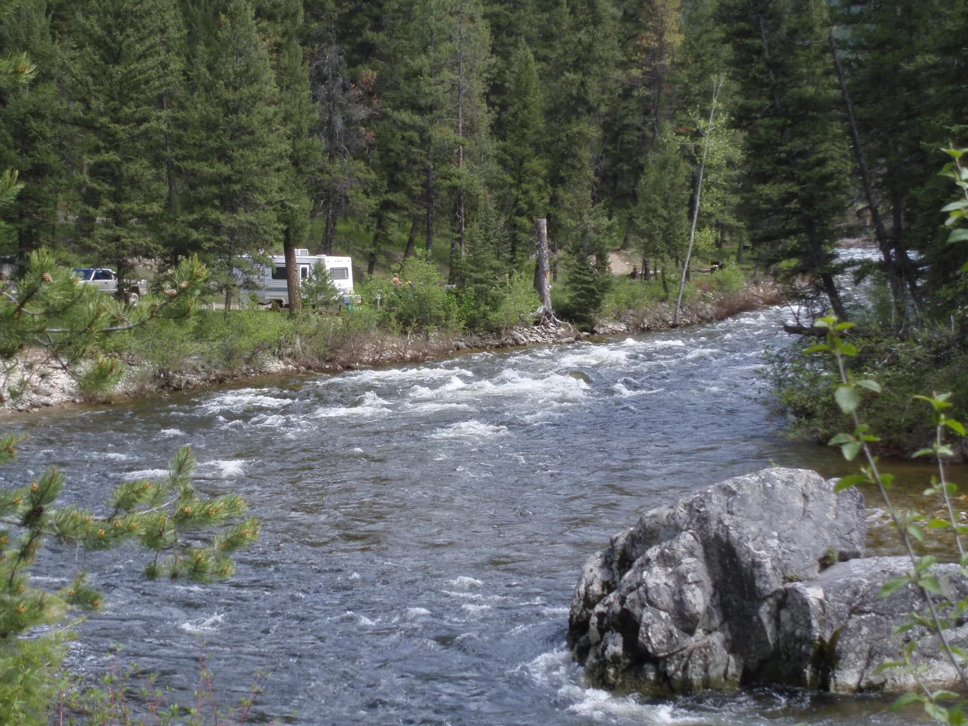
Two of Montana's most celebrated trout rivers form the eastern and western boundaries of the Lolo's core recreation area. The Clark Fork, flowing through Missoula, and the Blackfoot River, immortalized in Norman Maclean's "A River Runs Through It," both receive significant angling pressure but maintain strong wild trout populations. The forest's interior streams (Lolo Creek, Fish Creek, and the Ninemile Creek system) provide quality dispersed fishing with less competition.
Best Trails
Eight trails capture the range of the Lolo National Forest's terrain, from the beloved urban trails near Missoula to the remote wilderness interior.
Rattlesnake Creek Trail is the forest's most-used trail, running 6.4 miles into the Rattlesnake Wilderness from the trailhead at the edge of Missoula. The creek-side route is accessible to a wide range of hikers and is open to both foot travel and mountain bikes in the National Recreation Area section.
Stuart Peak Trail climbs 12 miles round trip to a summit at 8,562 feet with views across the Clark Fork drainage and into the Rattlesnake Wilderness. It is the most demanding hike in the Missoula front range.
Pattee Canyon Trail runs 5.2 miles through a forested canyon immediately east of Missoula, popular with trail runners and mountain bikers from the university community. The canyon provides shade and consistent terrain.
Marshall Mountain Trail climbs 7.6 miles round trip to the Marshall Mountain area east of Missoula, sharing terrain with a winter ski area and offering views of the city and the Clark Fork Valley below.
Fish Creek Trail follows a remote western drainage 8.8 miles through old-growth cedar and larch to a seldom-visited upper basin. This is among the most pristine and least-traveled drainages accessible by maintained trail.
Lolo Peak Trail tackles the forest's most prominent summit above Lolo, climbing 9.0 miles round trip to a rocky peak at 9,096 feet with commanding views of the Bitterroot Valley and the Lolo Pass area.
Big Creek Trail provides 7.0 miles of canyon hiking in a quiet drainage north of Missoula, with a moderate grade and extensive old-growth cedar-hemlock forest in the lower sections.
Sheriffs Flat Loop is a 5.0-mile loop on the bench above Missoula, offering wide valley views and an accessible circuit popular with families and beginning trail runners.
Permits and Passes
No permit is required for day hiking or dispersed camping on the Lolo National Forest as of 2026. Developed campgrounds charge $15 to $22 per night (as of 2026).
The America the Beautiful Annual Pass covers entrance fees at participating federal recreation sites. See our guides on the America the Beautiful pass for veterans and veteran benefits on national forests for details on free access programs available to qualifying individuals.
The Rattlesnake Wilderness has special fishing regulations. Consult Montana Fish, Wildlife and Parks for current rules before fishing any wilderness water.
Camping
Lolo Creek Campground sits along Lolo Creek south of Missoula on Highway 12, with 28 reservable sites serving as the main family camping option in the forest corridor near the city. It offers access to the Lolo Trail route and nearby fishing on Lolo Creek.
Lewis and Clark Campground sits along the Lochsa River near Lolo Pass, providing 18 sites with direct access to the historic trail corridor and the Lochsa fishing. Reservations are recommended in July and August (as of 2026).
Ninemile Remount Depot Campground serves the historic Ninemile Remount Depot area, which maintained pack strings for fire suppression work throughout the twentieth century. Fifteen sites are available first-come, first-served.
Squaw Rock Campground is a small, primitive site near Fish Creek with 10 first-come sites suited to hikers and anglers accessing the Fish Creek drainage.
When to Visit
May through June opens the valley-level trails around Missoula while higher routes still hold snow. The Blackfoot and Clark Fork rivers run high with snowmelt, which means excellent scenery but challenging access to some creek drainages.
July through August is peak season. Most trails are clear, wildflowers peak in the high country, and the long summer days suit both full-day hikes and leisurely evening walks. Trails near Missoula see their highest use during this period.
September through October brings fall color to the larch and aspen stands and significantly reduced crowds. Wildlife activity increases, particularly elk in the more remote drainages. Temperatures cool rapidly at elevation in October and snow is possible on higher routes.
Winter brings excellent cross-country skiing in the Rattlesnake and on groomed trails near Lolo. The lower-elevation canyon trails remain mostly accessible for snowshoeing.
Getting There
From Missoula: The forest begins at the city's edge. The Rattlesnake Wilderness trailhead is at the end of Van Buren Street, 10 minutes from downtown. Highway 12 west leads to the Lolo Pass corridor (60 miles, 1.5 hours). Most Missoula-area trailheads are paved and well-signed.
From Helena: Drive west on I-90 to Missoula, approximately 110 miles (2 hours). Helena serves as an eastern gateway for those approaching from central Montana.
From Spokane, Washington: Cross the Idaho panhandle to Missoula via I-90, approximately 200 miles (3.5 hours). Spokane provides the nearest major airport west of Missoula.
Practical Tips
Bear awareness is important throughout the Lolo. Black bears are common everywhere, and grizzlies are present in the more remote drainages. Carry bear spray and know how to use it. Our guide on bear canister requirements covers storage requirements for overnight travel.
The Rattlesnake Wilderness boundary separates wilderness-only travel (foot and horse) from the NRA section that allows mountain bikes. The distinction matters: stay on designated-use trails in each zone. Signs mark the boundary clearly.
Summer thunderstorms are routine from July onward. The exposed summit trails near Missoula see afternoon buildups. Start summit attempts early in the day. Check current conditions using the USFS checking guide.
Follow Leave No Trace principles particularly in the heavily used Rattlesnake NRA, where concentrated use on popular weekends can lead to social trails and off-trail impact.