Two Forests, One High-Country Experience
Medicine Bow-Routt National Forests is a combined administrative unit covering 2,222,000 acres across southeastern Wyoming and northwestern Colorado, managed together as a single forest despite spanning a state line. The Wyoming portion centers on the Medicine Bow Mountains, a subrange of the Rockies rising to 12,000 feet with the distinctive quartzite peaks of the Snowy Range visible from Laramie and I-80. The Colorado portion, the Routt National Forest, covers the Park Range above Steamboat Springs and extends south toward the Gore Range.
In Colorado and Wyoming, this forest represents one of the more overlooked public land complexes in the central Rockies, overshadowed by higher-profile forests to the south in Colorado and to the west in Wyoming. This obscurity works to the forest's advantage: the wilderness areas here receive dramatically less traffic than comparable terrain in Rocky Mountain National Park or the Indian Peaks, and the combination of high alpine lakes, Continental Divide views, and lodgepole pine landscape creates a satisfying high-country experience without the permit queues and crowded trailheads that define the Front Range.
Why Medicine Bow-Routt Stands Out
Snowy Range and the Medicine Bow Mountains
The Snowy Range Scenic Byway (Wyoming Highway 130) is one of the finest mountain drives in the northern Rockies, crossing the Medicine Bow Mountains at nearly 11,000 feet through a landscape of stark quartzite peaks, alpine lakes, and glacially carved basins. The rock here is ancient Precambrian quartzite, some of the oldest exposed rock in Wyoming, and it weathers into brilliant white and rust-colored ridgelines that give the range its popular name. Trailheads line the byway and provide access to day hikes ranging from easy lake loops to full summit routes.
Rawah Wilderness and Alpine Lakes
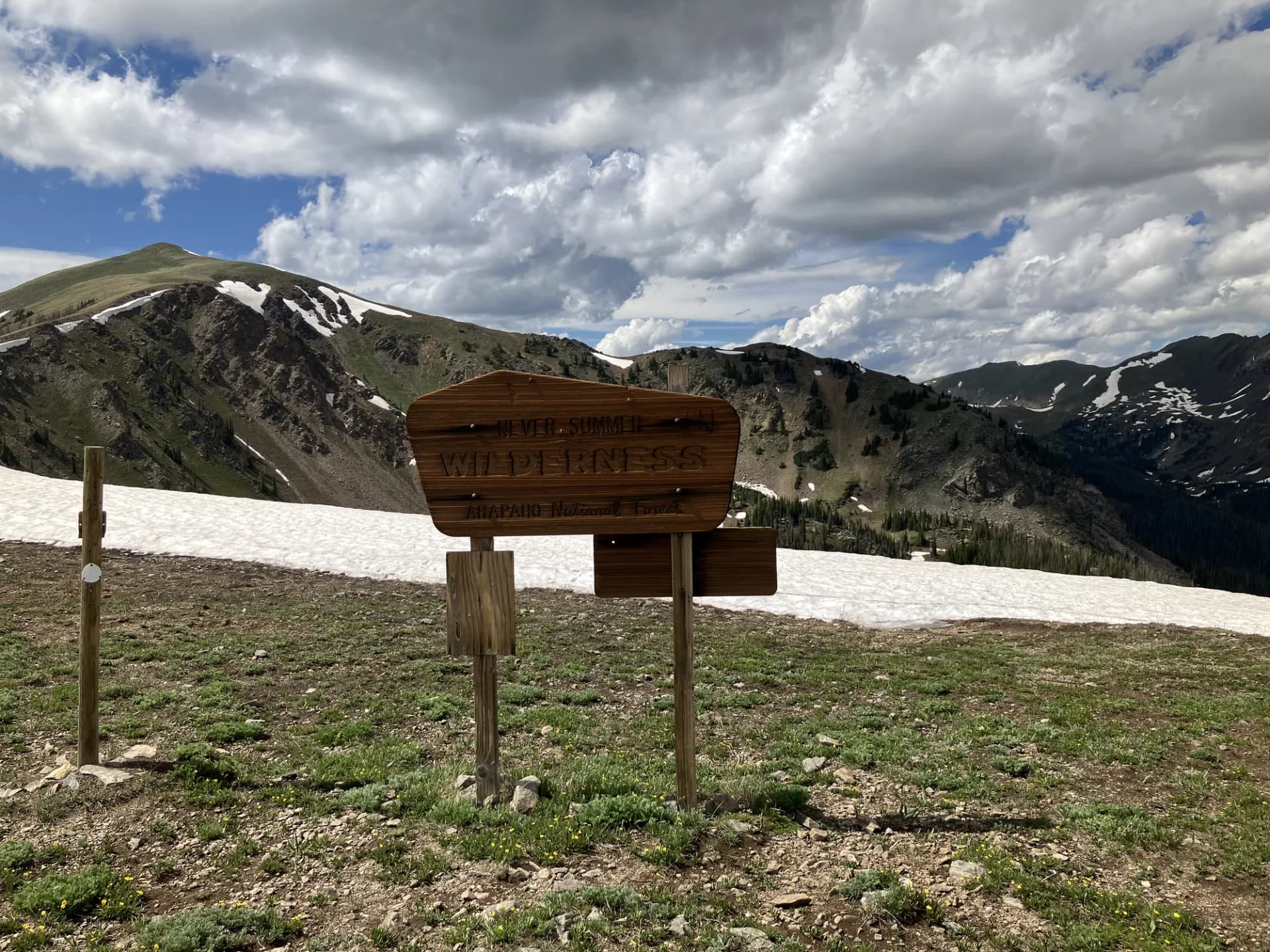
The Rawah Wilderness in northern Colorado protects 73,000 acres of the northern Park Range, containing 73 named and unnamed alpine lakes accessible by trails fanning out from the Laramie River and Big South Fork trailheads. The wilderness name comes from the Arapaho word for "wild." The terrain is relatively gentle by Colorado standards, making multi-day backpacking through the Rawah an approachable objective for hikers transitioning from day hiking to overnight travel.
Mount Zirkel Wilderness and the Park Range
Mount Zirkel Wilderness covers 160,000 acres of the Park Range above Steamboat Springs, Colorado, protecting terrain from 8,000 feet to over 12,000 feet. The wilderness contains the headwaters of the Elk River and numerous lakes and high-country routes. Mount Zirkel itself at 12,180 feet is the high point of the range and accessible by several trails from the Steamboat Springs side.
Best Trails
Medicine Bow Peak Trail (4.6 miles, out-and-back) climbs to the 12,013-foot summit of Medicine Bow Peak from the Snowy Range Scenic Byway, the most accessible high summit in the Wyoming unit.
Lake Marie Loop (3.0 miles, loop) circles Lake Marie along the Snowy Range Byway with Medicine Bow Peak as a backdrop, one of the most scenic short loops in the Wyoming Rockies.
Rawah Wilderness Lakes Loop (12.0 miles, loop) traverses the heart of the Rawah Wilderness in northern Colorado, visiting multiple alpine lakes in a loop backpack or long day hike.
Vedauwoo Trail (2.5 miles, easy-moderate loop) explores the Vedauwoo rock formation area near Laramie, a unique landscape of Sherman granite tors popular for rock climbing and scrambling.
Hahns Peak Summit Trail (5.6 miles, out-and-back) climbs to the summit of Hahns Peak in the Routt unit near Steamboat Springs, a former fire lookout site with views across the Park Range.
Mount Zirkel Trail (9.0 miles, out-and-back) climbs to the 12,180-foot summit of Mount Zirkel in the wilderness of the same name.
Big Creek Lakes Trail (4.0 miles, loop) circles the Big Creek Lakes in the Routt unit through open subalpine forest near the Wyoming border.
Lost Lake Loop (6.0 miles, loop) traverses the central Rawah Wilderness through a series of lakes and meadows in northern Colorado.
Permits and Passes
No permit is required for day hiking or dispersed camping in Medicine Bow-Routt National Forests or its wilderness areas (as of 2026). Developed campgrounds require reservations and fees ranging from $18 to $26 per night at most sites (as of 2026).
The America the Beautiful Annual Pass covers recreation fees at developed sites. Veterans and those with qualifying disabilities may qualify for free or reduced-cost passes. See America the Beautiful Pass for Veterans and Veteran Benefits in National Forests for details.
Camping
Sugarloaf Campground along the Snowy Range Byway is the primary developed campground for Medicine Bow Peak and Lake Marie access, with 55 sites and reservation availability through Recreation.gov.
Nash Fork Campground is another Snowy Range Byway option with 27 sites at a slightly lower elevation. Good access to the network of byway trailheads.
Seedhouse Campground in the Routt unit north of Steamboat Springs provides 24 sites with access to the Elk River drainage and Mount Zirkel Wilderness trailheads.
Big Creek Lakes Campground offers 54 sites near the Big Creek Lakes on the northern Colorado-Wyoming border, with excellent lake access and fishing.
When to Visit
Late June through July is when both units open fully. The Snowy Range Byway (WY-130) typically opens in late May but the high trails may hold snow into July. Wildflowers peak in the Rawah and Mount Zirkel meadows from late June through late July.
August is the most reliable window for high-country travel. Afternoon thunderstorms are common by mid-afternoon. Morning starts are essential above treeline. The alpine lakes are at their warmest for fishing.
September brings fall color to the aspen groves throughout both units, particularly beautiful in the Routt unit around Steamboat Springs. Crowds thin dramatically after Labor Day. Early snow can arrive in September above 11,000 feet.
October through May the high country is snowbound. Cross-country skiing and snowmobiling are popular through both units in winter. The Vedauwoo area near Laramie remains accessible and popular for winter rock climbing on mild days.
Getting There
From Laramie, WY: Wyoming Highway 130 west from Laramie enters the Medicine Bow Mountains in approximately 20 miles, reaching the main byway trailheads at 30 miles. About 45 minutes to the Snowy Range area.
From Steamboat Springs, CO: The Routt National Forest boundary begins less than 10 miles from downtown Steamboat Springs. The Seedhouse Road north provides access to Mount Zirkel Wilderness trailheads in about 30 minutes.
From Fort Collins, CO: US-287 north to WY-230 west into the forest's southern Colorado reaches, or north through Laramie to the Snowy Range. Approximately 65 miles to the forest boundary, about 1 hour 15 minutes.
Practical Tips
The Medicine Bow Mountains receive significant snowfall; the Snowy Range area averages over 200 inches of snow annually. Even in summer, afternoon thunderstorms can bring hail and lightning quickly above treeline. Starting any summit or ridge hike by 7 AM allows most parties to complete exposed terrain before afternoon weather develops.
Black bears inhabit both units. Food storage and bear canister requirements guidelines apply throughout the forest. Moose are common in the willow-lined drainages at all elevations; give them substantial space as they can be unpredictable.
The Rawah Wilderness requires a Wyoming or Colorado fishing license depending on which side of the state line the water lies. Check with the Laramie or Steamboat Springs ranger districts for clarification on specific lakes. Practice Leave No Trace principles throughout both units, and check conditions at checking conditions before you go before any visit, particularly for Snowy Range Byway opening dates and current wilderness conditions.