Nantahala National Forest covers 531,000 acres across the southwestern corner of North Carolina, making it both the largest national forest in the state and, according to USFS visitor data, the most visited national forest in the Eastern United States. The name comes from the Cherokee, roughly translated as "land of the noonday sun," a reference to the Nantahala Gorge where the canyon walls are tall enough to block sunlight until midday. That gorge, now famous for Class III whitewater rafting, cuts through the heart of the forest and defines the experience of thousands of visitors each year.
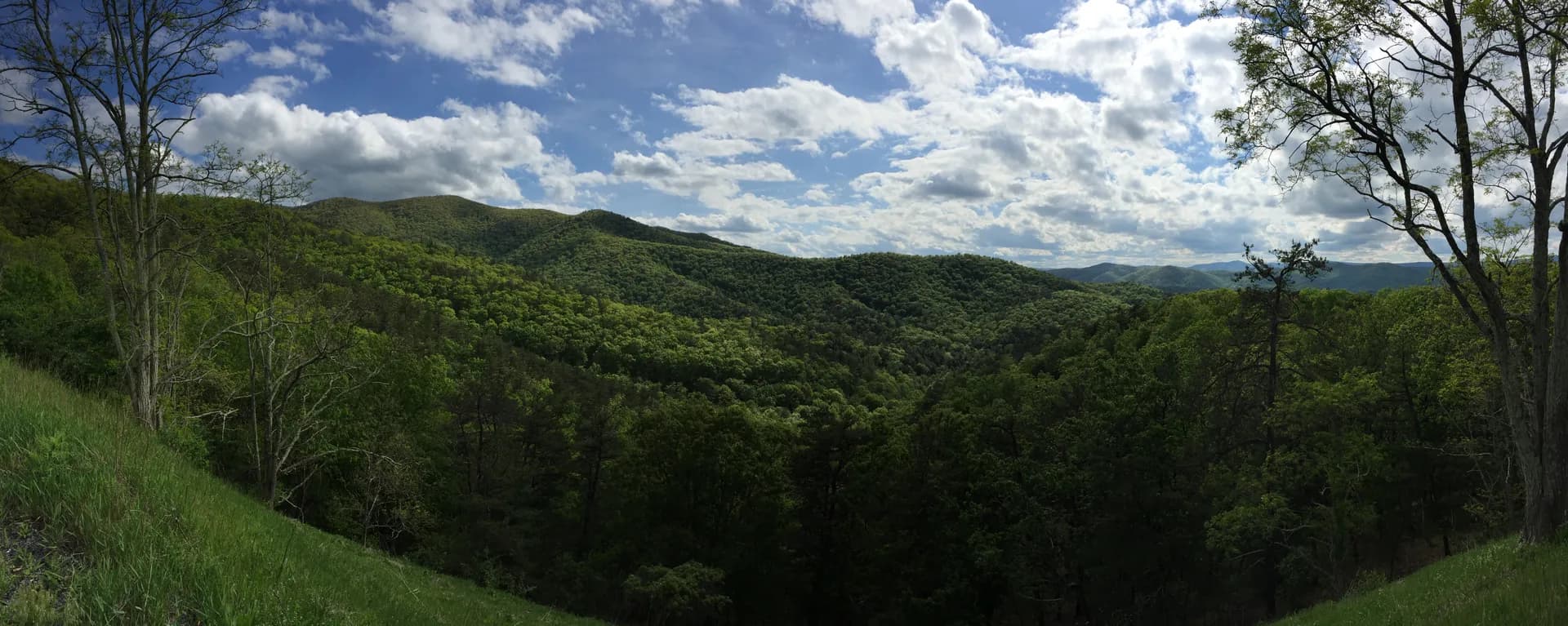
The forest spans parts of seven counties and is divided into four ranger districts. The terrain is classic Southern Appalachian: ridges and hollows, a mosaic of hardwood coves and spruce-fir summit zones, and waterfalls that drop off nearly every significant drainage. Elevations range from around 1,200 feet in the Hiwassee River valley to 5,499 feet at Standing Indian Mountain, one of the highest peaks in the southern Appalachians outside of the Smokies. The combination of elevation range and moisture-rich climate produces exceptional biodiversity, including rare endemic plant species and some of the richest salamander assemblages in North America.
The Appalachian Trail enters Nantahala from Georgia at Bly Gap and traverses through the southern section of the forest, passing through the Standing Indian Basin and Wayah Bald before continuing north into the Pisgah National Forest. This stretch of the AT is among the more challenging sections in the southern states, with significant elevation change and remote wilderness camping.
Why Nantahala Stands Out
Joyce Kilmer Memorial Forest. The Joyce Kilmer section is a 3,800-acre tract that contains some of the largest old-growth trees remaining in the Eastern United States. Yellow poplars (tulip trees) exceeding 20 feet in circumference and 100 feet in height grow in the coves here, alongside eastern hemlocks and oaks that predate European settlement. The forest is named for the World War I poet who wrote "Trees," and was dedicated to his memory in 1936. Very few areas in the eastern hardwood zone escaped the era of industrial timber harvest, which makes this grove genuinely rare. Walking through it changes your sense of what eastern forests once looked like at scale.
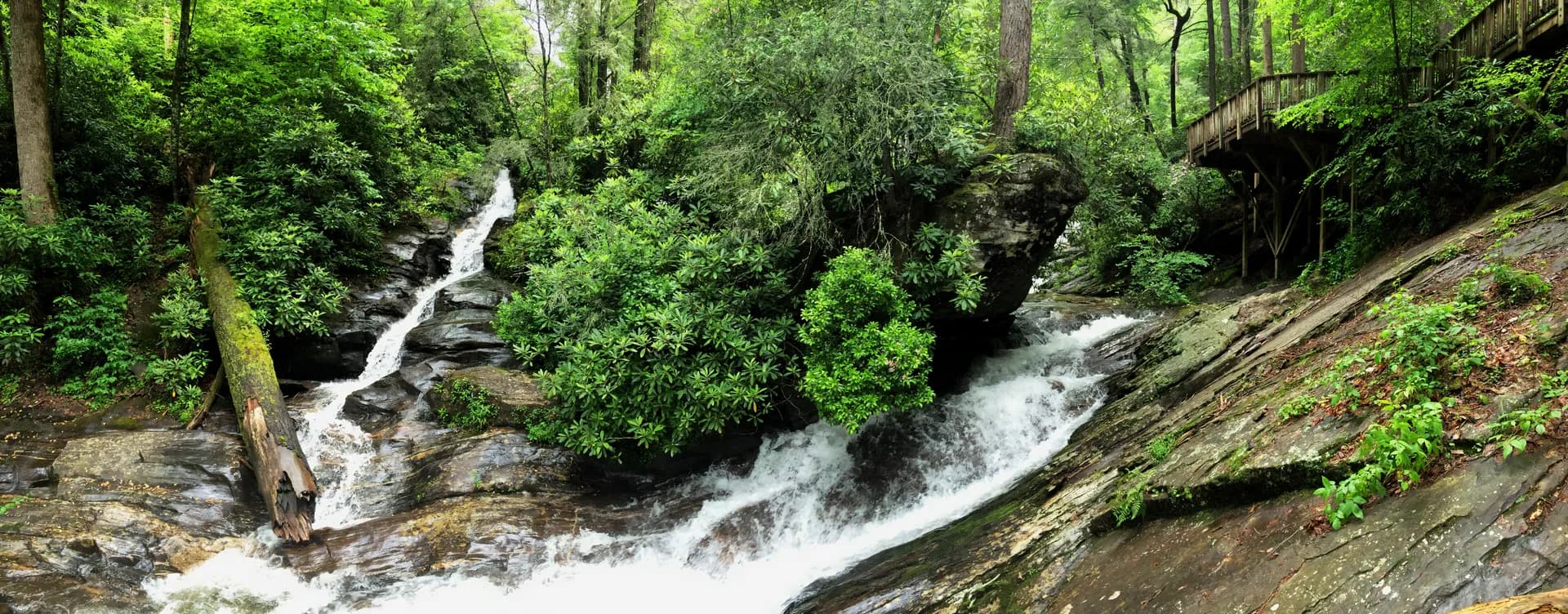
Waterfalls. Nantahala has a higher concentration of named waterfalls than almost any national forest in the eastern US. Whitewater Falls on the Chattooga River headwaters drops over 400 feet in a series of cascades, making it one of the tallest waterfalls in the East. The falls are accessible via a short trail from a developed trailhead. Cullasaja Gorge south of Highlands contains multiple named cascades visible from US 64. Plenty of unnamed falls reward hikers who follow streams off the main trail network.
Elevation diversity and wilderness. The seven designated wilderness areas ranging from the ellicott rock triangle at the Georgia-South Carolina-North Carolina border to the Standing Indian area create significant patches of protected backcountry. The Southern Nantahala Wilderness and Standing Indian Wilderness offer long-distance backpacking loops that rival anything in the region. The diversity of elevation zones, from warm cove forest to bald summits, compresses an enormous range of plant communities into a single forest unit.
Best Trails in Nantahala National Forest
The Joyce Kilmer Memorial Forest Loop is a 2.0-mile figure-eight loop through old-growth cove hardwood forest. The loop's short distance belies its impact: you spend an hour among trees that are hundreds of years old and as large as any remaining in the East. This is one of the most unusual hiking experiences in the Southeast and is worth a detour regardless of your broader itinerary in the region.
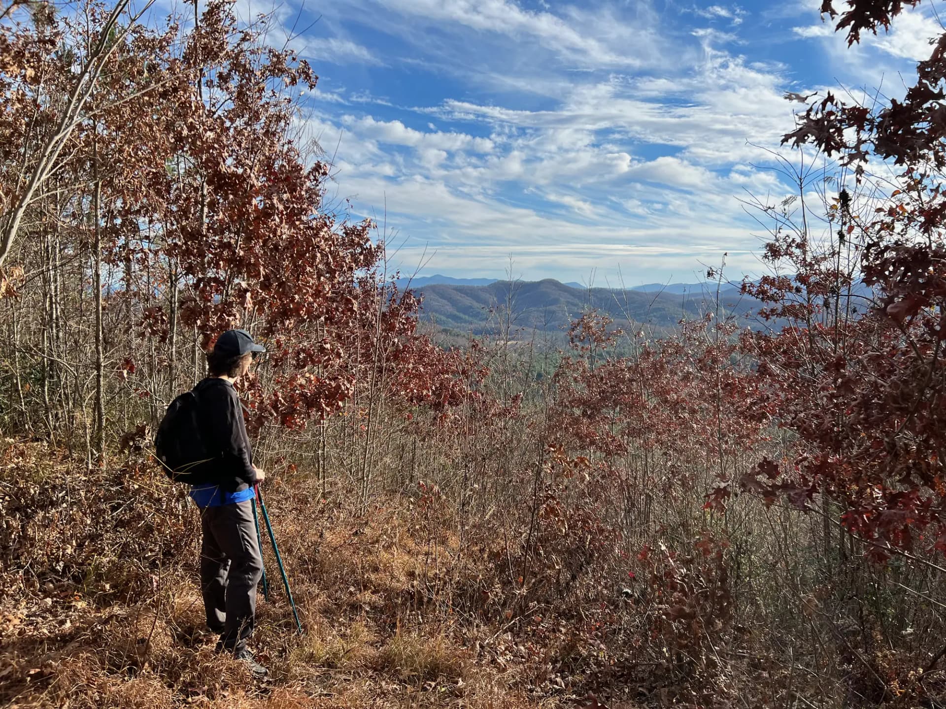
Standing Indian Mountain is the hardest and most rewarding summit hike in the forest. The 9.0-mile out-and-back climbs 2,400 feet to 5,499 feet, the highest point in the Georgia-North Carolina-South Carolina tri-state area south of the Smokies. The summit provides 360-degree views and sits on the Appalachian Trail. This hike is popular with AT section hikers.
Fires Creek Rim Trail is a 10.0-mile loop in the Fires Creek area that provides a wilderness ridgeline circuit with sustained views and remote backcountry camping options. This is a less-crowded alternative to the AT corridor for those who want a full-day moderate-hard loop.
Wayah Bald Trail provides access to a 4,627-foot summit with a historic stone observation tower. The 4.0-mile out-and-back offers some of the best 360-degree views in the southern Appalachians and intersects the AT at the summit.
Permits and Passes
Most trailheads in Nantahala National Forest require no permit or fee as of 2026. Some developed recreation areas charge a parking fee; verify current rates when planning. The Appalachian Trail corridor does not require a permit for day hiking. Some backcountry areas may require registration for large groups; check with the relevant ranger district.
The America the Beautiful annual pass covers day-use fees at developed sites. See the Veterans Benefits guide for information on free passes available to veterans.
Camping regulations vary by location. Review the national forest camping permit guide before overnight trips.
Camping
Standing Indian Campground near Franklin is the largest USFS campground in the forest and serves as a base camp for AT section hikers and those exploring the Standing Indian Basin. It is the only campground in the forest with full ADA-accessible facilities. Contact the Nantahala Ranger District at fs.usda.gov/nfsnc for current ADA facility conditions.
Jackrabbit Mountain Campground on Lake Hiwassee is one of the larger lakefront campgrounds in the forest, popular with families and boat campers. Tsali Recreation Area is oriented toward mountain biking and horse camping on the Fontana Lake peninsula.
Dispersed camping is permitted throughout most of the forest with no permit required as of 2026, provided campers follow Leave No Trace principles and applicable distance requirements from water sources and trails. See the LNT guide for full guidance.
When to Visit
Spring (April through May): Spring wildflower season is exceptional in the cove forests, particularly in the Joyce Kilmer area. Trillium, bloodroot, and jack-in-the-pulpit carpet the forest floor. Stream flows are high and waterfalls are at their most impressive.
Summer (June through August): Full access to all trails. High elevations are cool even in summer. The forest is green and lush. Crowding at popular destinations like Joyce Kilmer and Whitewater Falls is most pronounced on summer weekends.
Fall (October through November): Fall color moves through the forest over a several-week window as temperatures drop from the high summits down to the valleys. Mid-October at elevation; early November in the coves. Excellent season for AT section hiking.
Winter (December through March): Higher elevations may have ice and snow. Lower elevation coves remain accessible. The forest is quiet and some trails provide good birding for winter species.
Getting There
From Asheville: Take I-26 west to US 74 west toward Waynesville and Andrews, or take US 19/23 south to Cherokee and then US 74. Most ranger districts are 60-90 minutes from Asheville depending on destination.
From Atlanta: Take I-75 north to I-575/US 76 west to Blue Ridge, GA, then US 64 west into the Highlands area, or take US 19/129 north from Gainesville through Murphy. Atlanta to the forest is approximately 2 to 2.5 hours depending on destination.
The forest is not served by public transit. Most trailheads are accessible by standard passenger vehicles.
Practical Tips
- Black bears are abundant throughout the forest. Store food in bear canisters or hang at camp. See the bear canister requirements guide.
- Eastern diamondback and timber rattlesnakes are present at lower elevations. Watch where you step and place your hands. Reference official USFS wildlife guidance for current precautions.
- The AT corridor sees high hiker traffic in spring and fall. If you want solitude, explore the off-AT wilderness trails in the Fires Creek and Snowbird areas.
- Many roads in the forest are unpaved and some require high-clearance vehicles. Check road conditions before heading to remote trailheads.
Planning Your Trip
The USFS North Carolina National Forests website at fs.usda.gov/nfsnc covers all four ranger districts. Current conditions, permit information, and campground reservations are available there.
For guidance on planning your first overnight trip in a national forest, see the camping permit guide and the conditions guide.