Sequoia National Forest occupies 1.2 million acres of the southern Sierra Nevada, stretching from the foothill oak woodlands above Porterville to the granite ridges and high meadows of the Kern Plateau. Unlike the more-visited Sequoia National Park to the north, the national forest operates under a multiple-use management model that keeps most trails uncrowded and most trailheads free of entry fees. The forest takes its name from the giant sequoia groves that anchor its western slopes, but the terrain extends far beyond those groves into some of the most remote and varied backcountry in California.
The forest encompasses three wilderness areas: the Golden Trout Wilderness on the Kern Plateau, the Jennie Lakes Wilderness along the Kings Canyon boundary, and a portion of the South Sierra Wilderness. Each offers a different character. The Golden Trout Wilderness is big, lonely, and sky-wide, a high plateau cut by glacially formed creek drainages. The Jennie Lakes area is more intimate, with granite lakes tucked beneath forested ridges. Combined, the forest's wilderness corridors provide over 300,000 acres of roadless terrain. For a broader look at how national forests compare to national parks, see our national forest vs. national park guide.
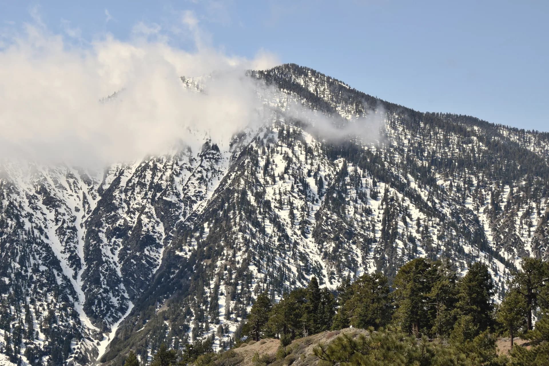
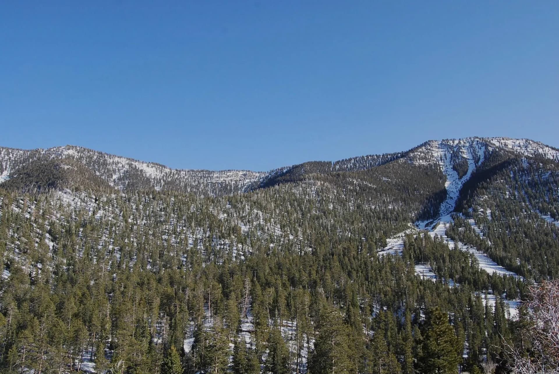
Elevations range from around 1,000 feet in the Tule River foothills to over 12,000 feet on peaks along the crest. That range means the forest hosts an unusual diversity of plant communities: blue oak and gray pine in the low foothills, mixed conifer and giant sequoia at mid-elevations, red fir and lodgepole pine in the subalpine zone, and open granite and alpine meadows at the top. The Kern River, which cuts a deep canyon through the eastern portion of the forest, adds another dimension entirely.
Why Sequoia National Forest Stands Out
The Kern River Canyon
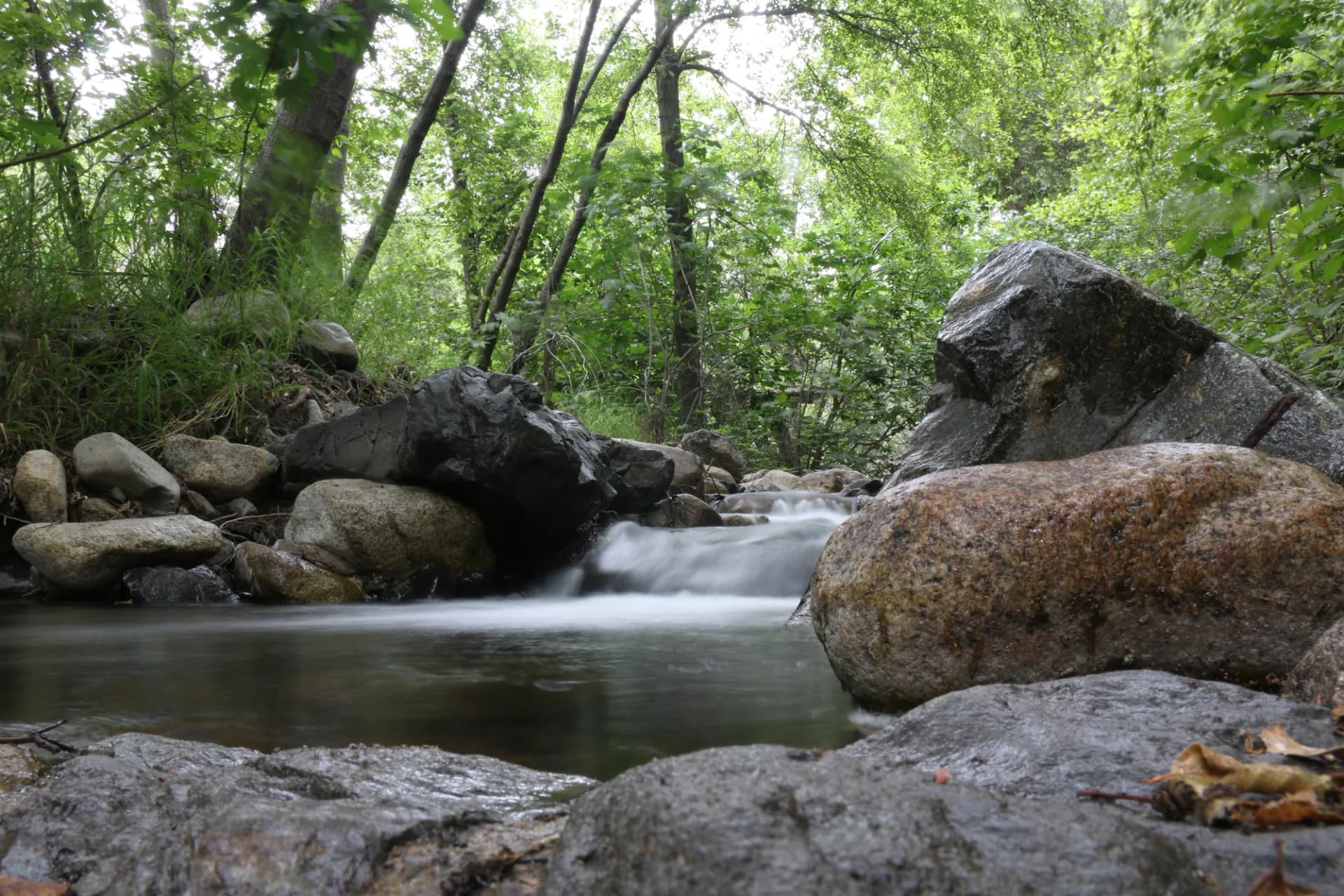
The Kern River flows south through a fault-controlled canyon that cuts straight through the heart of the forest. The upper Kern is one of the longest stretches of free-flowing river in California, and the lower reaches near Kernville support a well-developed rafting and kayaking scene. For hikers, the Kern River Trail offers miles of flat, accessible walking along the river corridor, with swimming holes and fishing access throughout. The canyon walls rise several thousand feet above the river, making even a short walk feel dramatic.
Historic Fire Lookouts
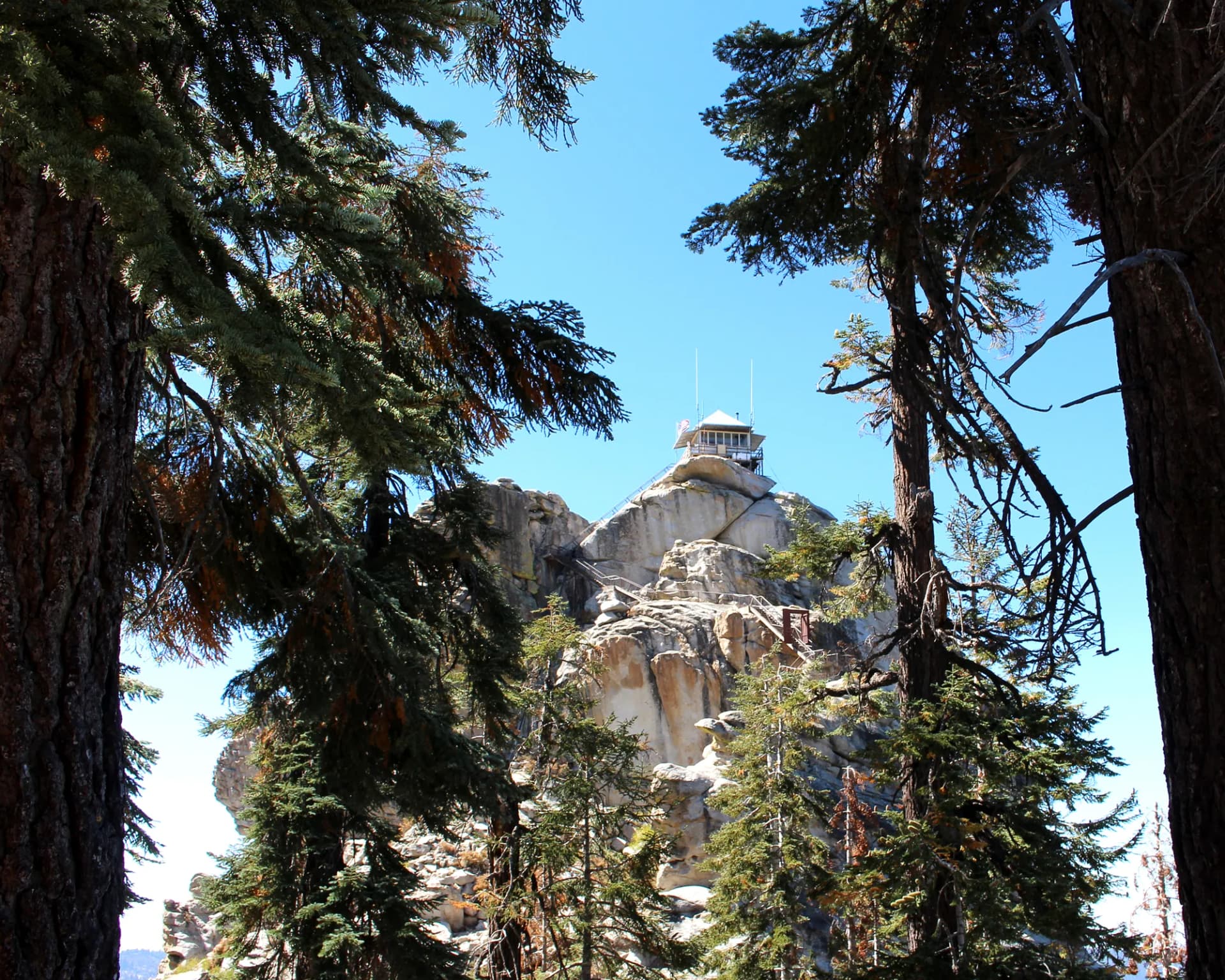
Sequoia National Forest maintains two staffed fire lookouts that are accessible by trail: the Jordan Peak Lookout at 9,100 feet and the Needles Lookout, which sits atop a dramatic granite formation above Johnsondale. Both are working Forest Service facilities from the early twentieth century. The views from each span enormous distances across the southern Sierra Nevada and, on clear days, extend to the Coast Ranges to the west and the White Mountains to the east.
The Tule River Watershed
The Tule River drains the western slopes of the forest through a series of forks that converge near Springville. The Tule River Trail follows the North Fork through a mixed conifer canyon with year-round water, swimming holes, and access to giant sequoia groves higher up. This corridor is the most accessible part of the forest from the San Joaquin Valley and sees the highest visitation, but the trailheads still feel uncrowded compared to anything in the national park system.
Best Trails in Sequoia National Forest
The forest's 860 miles of trail cover a wide range of difficulty and character. The Jordan Peak Lookout trail is the most popular summit hike, a 4.4-mile out-and-back that gains 1,200 feet to a staffed fire lookout with 360-degree views. The Needles Lookout is shorter but more dramatic at the top, finishing on a narrow granite spire with an exposed cabin perched on the rock.
For the best backcountry experience, the Golden Trout Wilderness Loop covers 12 miles of high plateau terrain, crossing creek drainages and open meadows between 9,000 and 10,500 feet. This requires an overnight stay and a free self-issue wilderness permit. The East Creek Loop is a good middle-ground option for hikers who want a full day of challenging terrain without a backpacking commitment.
The Kern River Trail stands alone as the best flat, accessible hike in the forest. Eight miles of river corridor walking with frequent swimming access makes it the right choice for hot summer days or for hikers who want distance without elevation.
Permits and Passes
Most day hikes in Sequoia National Forest require no permit. Overnight trips into the Golden Trout Wilderness require a free self-issue permit available at the trailhead register. A campfire permit is required for any open fire below 9,000 feet at any time of year; these are free and available from the Forest Service website. During periods of high fire danger, the Forest Service issues campfire restrictions that may extend above 9,000 feet or ban fires entirely. Check current fire restrictions at recreation.gov or the Sequoia National Forest website before any visit.
The America the Beautiful pass covers day-use fees at some developed sites in the forest. Veterans and their families may be eligible for a free pass. See our America the Beautiful pass guide for veterans for eligibility details.
Camping in wilderness areas requires the free wilderness permit but no fee. Reservable campgrounds can be booked through Recreation.gov. First-come, first-served sites fill quickly on summer weekends.
Camping
Quaking Aspen Campground at 7,800 feet is the most comfortable base camp for high-elevation hiking. Its 32 sites are reservable through Recreation.gov and sit within easy reach of the Kern Plateau trailheads. The campground has vault toilets and piped water during the operating season.
Tule Meadow and Frog Meadow campgrounds are smaller, first-come, first-served operations at similar elevations on the forest's western side. Both fill on summer weekends but are often available midweek. Dispersed camping is permitted throughout the forest outside of posted closure areas, provided you camp at least 200 feet from any water source, trail, or road.
The Kern Valley along State Route 155 and Kernville Road has several private campgrounds and RV parks that provide another base for exploring the canyon.
When to Visit
May through October is the general season, but the timing varies significantly by elevation. Low-elevation trails along the Tule River and Kern Canyon are accessible by March and pleasant through early June before heat becomes a factor. Mid-elevation trailheads above 6,000 feet open up in May in most years. High-elevation roads and trailheads above 8,000 feet may not clear until June in heavy snow years.
July and August bring peak wildflower bloom to the Golden Trout Wilderness, along with afternoon thunderstorms that develop reliably from late June through early September. Plan to be off exposed ridges and summits by early afternoon. Temperatures in the Kern Canyon can exceed 100 degrees Fahrenheit in midsummer, making riverside hiking best in early morning.
September and October are the best months overall: clear skies, cooler temperatures, fall color in the aspen groves at higher elevations, and significantly fewer people on the trails.
Before any trip, check current conditions at the Forest Service alerts page and via InciWeb for fire information.
Getting There
The main western access to Sequoia National Forest is via State Route 190 east from Porterville, which climbs to Quaking Aspen and the Kern Plateau. Allow 90 minutes from Porterville to reach upper-elevation trailheads.
The Kern Canyon is accessed via State Route 178 east from Bakersfield to Lake Isabella, then north on Kernville Road. This route is lower and generally snow-free year-round. Johnsondale and the Needles area are reached via a forest road connecting Kernville to the upper forest; this road can be rough in spots.
Cell service is limited throughout most of the forest. Download offline maps before leaving cell range. The Forest Service Porterville office serves as the primary ranger station for the western side of the forest.
Practical Tips
- Water is available at most developed campgrounds during the operating season, but backcountry water must be treated. A filter or chemical treatment is standard practice in the Sierra Nevada.
- Many hikers carry 2 to 3 liters on full-day hikes, though individual needs vary with temperature and exertion.
- Bears are active throughout the forest. A bear canister is required in the Golden Trout Wilderness for overnight trips. Review current bear canister requirements before your visit.
- The forest has no entrance fee, but some developed day-use areas charge a parking fee. An America the Beautiful pass covers most of these.
- High-clearance vehicles are recommended for some forest roads, particularly those accessing the Kern Plateau from the south.
Planning Your Trip
Sequoia National Forest rewards visitors who come with some flexibility. The forest's scale means that trail conditions, road access, and fire restrictions can vary dramatically across different drainages. Before any trip, check the Sequoia National Forest website for current road and trail conditions.
The forest pairs well with a visit to Kings Canyon National Forest or nearby national forests in the southern Sierra. For an overview of leave-no-trace practices that apply throughout the forest, see our Leave No Trace guide.