Overview
Umpqua National Forest covers 983,000 acres of the western Oregon Cascades in southern Oregon, stretching from the North Umpqua River canyon at 1,000 feet to the 9,182-foot summit of Mount Thielsen. The forest encompasses four wilderness areas, more than 520 miles of trails, and one of the most concentrated waterfall systems in the Pacific Northwest.
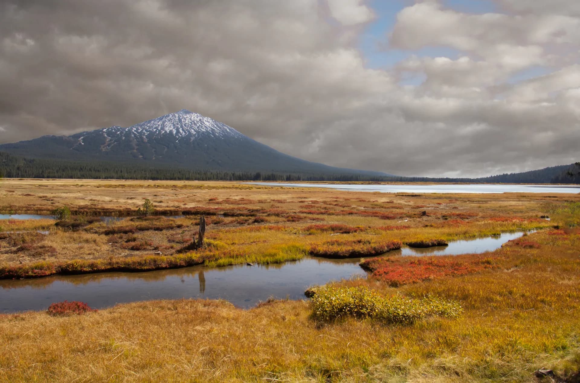
The North Umpqua River is the forest's defining feature: a designated wild and scenic river that carved a deep canyon through layers of volcanic rock over millions of years. Dozens of waterfalls drop from tributary creeks into the canyon, several of them among the most impressive in Oregon. Diamond Lake, at 5,183 feet near the forest's eastern boundary, draws summer crowds for boating, fishing, and cycling.
Why Umpqua National Forest Stands Out
The North Umpqua River and Its Waterfalls
Highway 138 follows the North Umpqua upstream from Roseburg into the forest, and the roadside and short-trail waterfalls along this corridor are among the most accessible in the state. Susan Creek Falls, Watson Falls, and Toketee Falls (just outside the forest boundary but a standard stop) are all within a short drive of each other. The 79-mile North Umpqua Trail runs the full length of the river corridor and is one of Oregon's great long-distance trails.
Diamond Lake
Diamond Lake sits in a volcanic basin with Mount Thielsen rising to the northeast and Mount Bailey to the southwest. The lake is 3,000 acres and remarkably clear, supporting a managed rainbow trout fishery. The Diamond Lake Resort provides full services including boat rentals, lodging, and a restaurant. The paved loop around the lake is one of the easier family cycling routes in the Oregon Cascades.
Mount Thielsen Wilderness
Mount Thielsen is nicknamed the "Lightning Rod of the Cascades" for its narrow, lightning-eroded spire. The summit ridge is a technical scramble requiring Class 3 or easier Class 4 moves depending on the chosen line, making it accessible to confident hikers without full mountaineering equipment. The trail approaches through the Mount Thielsen Wilderness, offering excellent volcanic scenery along the way.
Best Trails
The Susan Creek Falls Trail is a 2.4-mile out-and-back along the North Umpqua River to Indian Mounds and Susan Creek Falls, one of the most popular introductory hikes on the river corridor.
The Watson Falls Trail is a short 0.8-mile out-and-back to Watson Falls, the third-tallest waterfall in Oregon at 272 feet. One of the most impressive short walks in the forest.
The Mount Thielsen Trail is a 10.6-mile out-and-back to the base of the distinctive 9,182-foot summit spire, one of the most recognizable peaks in southern Oregon.
The Diamond Lake Loop is a gentle 11.6-mile circuit around Diamond Lake on a paved and packed gravel path, accessible to hikers and cyclists alike.
The Rogue-Umpqua Divide Trail is a 14.2-mile out-and-back along the high divide separating the Umpqua and Rogue River drainages, with sweeping views across both watersheds.
The North Umpqua Trail Steamboat Section is an 8.4-mile point-to-point or out-and-back along the most scenic central section of the 79-mile North Umpqua Trail, following the river through canyon old-growth.
The Umpqua Hot Springs Trail is a 0.4-mile walk to a natural geothermal pool above the North Umpqua River, one of the most popular backcountry hot spring destinations in Oregon.
The Bradley Creek Trail is a 7.6-mile out-and-back into the Rogue-Umpqua Divide Wilderness through old-growth Douglas fir and to a remote high-country ridgeline.
Permits and Passes
No permit is required for day hiking or dispersed camping in Umpqua National Forest or its wilderness areas (as of 2026). The Umpqua Hot Springs area requires a Northwest Forest Pass for parking, at $5/day or $30/year (as of 2026).
Developed campground reservations are handled through recreation.gov. Diamond Lake Campground books quickly for summer weekends; reserve 6 months in advance.
Veterans and active military receive discounted access through the America the Beautiful Pass. See America the Beautiful Pass for Veterans and Veteran Benefits at National Forests.
Camping
Diamond Lake Campground is the largest campground in the forest, with 250 sites across multiple loops adjacent to the lake. Flush restrooms, drinking water, and boat launch access. Reservable through recreation.gov at approximately $24/night (as of 2026), open May through October.
Susan Creek Campground offers 33 sites along the North Umpqua River, with flush restrooms and direct river access. Reservable at $18/night (as of 2026), open May through October.
Horseshoe Bend Campground has 24 sites on a river bend section of the North Umpqua, with vault toilets. Reservable at $20/night (as of 2026), open May through September.
Dispersed camping is available throughout the forest outside developed areas, free of charge (as of 2026). Camps must be 100 feet from water sources.
When to Visit
April through June brings peak waterfall flow on the North Umpqua corridor. The lower-elevation trails are snow-free by April, making spring an excellent time for waterfall hikes even before higher terrain opens.
July through August is peak season for Diamond Lake and the Cascades high country. All trails are typically open. Mount Thielsen is best accessed in July and August when the summit approach is snow-free.
September through October offers the best conditions for long-distance trail travel. The North Umpqua Trail is excellent in September with comfortable temperatures and reliable water sources.
November through March, snow closes most upper forest roads and wilderness trails. Cross-country skiing is available near Diamond Lake in winter.
Getting There
From Roseburg (45 miles, 1 hour): Highway 138 east from Roseburg follows the North Umpqua River directly into the forest. This is the main access road for the waterfall corridor and all North Umpqua River campgrounds. Roseburg has full services.
From Medford (75 miles, 1 hour 30 minutes): Highway 62 north from Medford connects to Highway 230, which leads to Diamond Lake from the south. This is the most direct route for the Diamond Lake area.
From Eugene (105 miles, 2 hours): Interstate 5 south to Roseburg, then Highway 138 east. Eugene provides full urban services including REI and outdoor outfitters for trip preparation.
Practical Tips
The North Umpqua corridor receives heavy use on summer weekends. Umpqua Hot Springs in particular is extremely crowded on Friday and Saturday nights from June through September; weekday visits provide a dramatically different experience.
Fire restrictions apply throughout the forest in summer. Check current Stage 1 and Stage 2 restrictions before any campfire. See Checking Conditions Before You Go for what to check.
Black bears are common throughout the forest. Store food in bear canisters or bear boxes. Review Bear Canister Requirements for wilderness overnight trips.
The North Umpqua River is fast-moving and cold; do not wade or swim in the main river. The canyon sections along the trail can be exposed. Practice Leave No Trace 7 Principles on all trails, especially around the heavily used waterfall areas and hot springs.